Places near here
Photo credits
- National Inventory of Architectural Heritage
- Nigel Thompson, Geograph · CC BY-SA 2.0
- Mike Searle, Wikimedia Commons · CC BY-SA 2.0
- Andy Beecroft, Geograph · CC BY-SA 2.0
- Mac McCarron, Geograph · Creative Commons Attribution-ShareAlike 2.0
- Hywel Williams, Geograph · CC BY-SA 2.0
- Antiqueight, Wikimedia Commons · CC BY-SA 4.0
- Jim Woodward-Nutt, Wikimedia Commons · CC BY-SA 2.0
- Jonathan Thacker, Geograph · Creative Commons Attribution-ShareAlike 2.0
- Tim FitzGerald, Geograph · CC BY-SA 2.0
- John M, Geograph · CC BY-SA 2.0
- Guliolopez, Wikimedia Commons · CC BY-SA 4.0
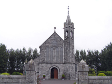 Catholic Church of the Sacred Heart of JesusChurch/chapel · 189 yd
Explorer Tom Catholic Church of the Sacred Heart of Jesus in Mogeely was built in 1909 with some serious stone masonry skills. The battered bell tower and rusticated limestone make it look like it’s ready to defend its turf. Check out the snecked stonework!
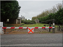 level crossing255 yd
Explorer Tom Level crossing in Mogeely is a railway relic from 1860 that stopped running in 1963 but still stands there like it’s got somewhere to be. It’s rare now because everyone replaced them with bridges, which are just boring overpasses. A good place to pretend you’re catching the last train to nowhere.
 Castlemartyr CastleCastle · 1.5 mi
Explorer Tom Castlemartyr Castle in County Cork was built in the mid-1500s for a seneschal chosen by James, Earl of Ormond. It's now a ruin next to a luxury hotel. Take a pic for me of that peaceful yet turbulent vibe!
 N25 Picnic SitePicnic place · 1.8 mi
Explorer Tom N25 Picnic Site was designed by a mother-in-law who hated traffic and loved passive aggression. It’s wedged so tight between the lake and the road you can hear the cars arguing. Stand on the spot and imagine the gossip it's heard.
 Grave YardGraveyard · 1.9 mi
Explorer Tom Graveyard in Castlemartyr is an overgrown yard with an earthen bank and a causewayed entrance, which sounds like a very old parking lot. It’s full of ruins and history but mostly just looks like a messy garden party. Bring a friend who talks too much and let the place shut them up.
 Ballintotis Castle (in Ruins)Castle, tower house · 2.5 mi
Explorer Tom Ballintotis Castle is standing to full height in level pasture, which means it hasn’t fallen over yet, so it’s doing better than most of my relationships. It’s a small square tower with a pointed arch that’s lost its jambs. Sit on a wall near it and pretend you're in a painting.
 Clonmult Ambush SiteBattlefield · 4.0 mi
Explorer Tom Clonmult Ambush Site in County Cork is basically a dating profile that says 'likes surprise attacks and running away,' which is honestly kind of attractive if you ignore the blood. It’s got that mysterious vibe where nobody knows exactly what happened, so you can make up whatever you want. Practise your Irish on it, it won't correct you.
 Jameson Distillery MidletonHeritage attraction · 5.0 mi
Explorer Tom Jameson Distillery Midleton in County Cork has a ghost who is too lazy to haunt the place properly. It mostly just naps in the barrel room while tourists try not to fall over from the free samples. Bring wellies and low expectations, leave delighted.
 St Laurences Well (covered)Holy well · 5.6 mi
Explorer Tom St Laurences Well in Garrylaurence has been doing this for two hundred years and still looks fresh off the block. It’s got a concrete roof, which is a bit of a fashion crime, but hey, it works. Tell the kids it's a castle. Close enough.
 Ballybrannigan BeachBeach / strand · 9.3 mi
Explorer Tom Ballybrannigan Beach has a secret it would tell after a few pints: it once swallowed a entire picnic basket without a chomp. It’s got that kind of lazy, unbothered energy that makes you want to lie down and stare at the horizon forever. The waves are gentle, like they’re apologising for existing. Linger, it's not going anywhere and neither should you.
 InchBeach / strand · 11 mi
Explorer Tom Inch is up to something when nobody’s looking, probably rearranging the shells or plotting a tiny rebellion against the incoming tide. You just have to trust that it knows what it’s doing with all that sand. Go at sunset and thank me later.
 Titanic Memorial GardenHeritage attraction · 11 mi
Explorer Tom The Titanic Memorial Garden would tell the place that replaced it to grow up and stop being so dramatic about the whole thing. It’s just a garden, mate, don’t make it into a soap opera. Stick around for the light changing, it's a show.
More archaeology and monuments in County Cork · All of County Cork

What do you know about this place?Tap to add a comment or ask a question