
What is recorded here
From the National Monuments Service (Archaeological Survey of Ireland) record GA097-114001
Places near here
Photo credits
- Maker not stated on source page, en.wikipedia.org
- Mike Searle, Geograph · CC BY-SA 2.0
- Maker not stated on source page, commons.wikimedia.org
- National Inventory of Architectural Heritage
- Maker not stated on source page, www.flickr.com
- Maker not stated on source page, tr.pinterest.com
- Maker not stated on source page, www.visitgalway.ie
- Kmcnamee, Wikimedia Commons · CC BY-SA 4.0
 Kiltullagh Church (in ruins)Church · 11 yd
Explorer Tom Kiltullagh Church in Kiltullagh North would tell you it has great references from 1838, even though half its walls are…
 Kiltullagh HouseHouse, 17th century · 149 yd
Explorer Tom Kiltullagh House almost got sold off as a prize horse at the fair before someone realised it was actually made of…
 Fairy fort / earthen ringfort in Kiltullagh NorthFairy fort / earthen ringfort · 391 yd
Explorer Tom Fairy fort / earthen ringfort in Kiltullagh North sounds like it’s snoring at night. All that’s left is a mound of…
 CastleCastle, unclassified · 423 yd
Explorer Tom Castle in Kiltullagh North and South is unclassified, which is fancy talk for 'we have no idea what this actually is.'…
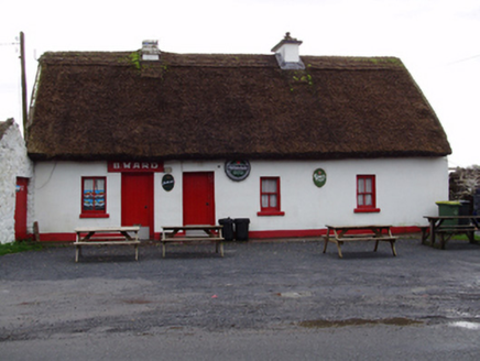 B. WardHouse · 489 yd
Explorer Tom B. Ward house in Clogharevaun would order a chipper with extra vinegar and no questions asked. It’s a vernacular gem…
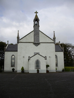 Catholic Church of Saint Peter and Saint PaulChurch/chapel · 547 yd
Explorer Tom Catholic Church of Saint Peter and Paul in Clogharevaun would order a chipper with extra gravy and no onions, hands…
 Fairy fort / stone ringfort in Kiltullagh SouthFairy fort / stone ringfort · 921 yd
Explorer Tom Fairy fort / stone ringfort in Kiltullagh South has a family tree that’s mostly made up and one or two cousins who are…
 Kiltullagh BridgeBridge · 1001 yd
Explorer Tom Kiltullagh Bridge thinks the road leading to it is a total mess of drainage schemes and bad decisions. Its rock-faced…
 Fairy fort / stone ringfort in GreyfordFairy fort / stone ringfort · 1086 yd
Explorer Tom Fairy fort / stone ringfort in Greyford is guarding its secrets better than a miser with gold. Legends say it only…
 Fairy fort / earthen ringfort in KnockatogherFairy fort / earthen ringfort · 1247 yd
Explorer Tom Fairy fort / earthen ringfort in Knockatogher would bring a half-eaten sandwich to any party and expect everyone to…
 Clogharevaun Castle (in ruins)Castle, tower house · 1653 yd
Explorer Tom Clogharevaun Castle overlooks a river bend and commands a crossing point, which is very bossy of it. Hugh McSwyne owned…
 Killimordaly Hurling Club GAA pitchGAA ground · 1.9 mi
More archaeology and monuments in County Galway · All of County Galway

What do you know about this place?Tap to add a comment or ask a question