Places near here
Photo credits
- National Inventory of Architectural Heritage
- Paul O'Farrell, Geograph · CC BY-SA 2.0
- David Hawgood, Geograph · CC BY-SA 2.0
- JackStonePGD, Wikimedia Commons · CC BY-SA 3.0
- Andreas F. Borchert, Wikimedia Commons · CC BY-SA 4.0
- Alex Passmore, Geograph · CC BY-SA 2.0
- Michael Dibb, Geograph · CC BY-SA 2.0
- Mike Searle, Geograph · CC BY-SA 2.0
- Sean O Briain, Geograph · CC BY-SA 2.0
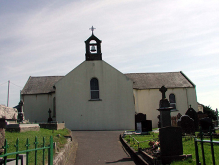 Catholic Church of the Holy CrossChurch/chapel · 100 yd
Explorer Tom Catholic Church of the Holy Cross claims it’s actually older than the concept of Tuesday itself. It predates Catholic Emancipation by a decade, which makes it feel like a proud grandparent at a party. Tap on the wall gently to check if the foundation stones are still arguing about their age.
 HayesHouse · 114 yd
Explorer Tom Hayes in Leckaun would post a selfie of its thatch roof with the caption 'Living my best low-life history' right now. It’s got those thick walls and battlements that make it look like a tiny fortress guarding nothing but a quiet street. Smile for the camera, mate.
Fairy Bush LoopWalking route · 1192 ydExplorer Tom Fairy Bush Loop would have made Saint Patrick blush, telling him he missed a few spots with his snake-chasing and left some very confused fairies behind. It’s got that magical vibe going on, but mostly just because the fog rolls in and makes everything look like a horror movie. Bring a map, get lost anyway, that's the fun.
 Harbour and Park walk.Walking route · 1.1 mi
Explorer Tom Harbour and Park walk keeps its secrets tight until after a few pints, when it starts spilling the beans about which boat captain kissed whom behind the shed. It’s got that salty, gossipy energy, smelling of tar and old rumours that refuse to die no matter how much wind blows through. Spot the oldest stone and give it a name.
 Rathmoylan CoveBeach / strand · 2.5 mi
Explorer Tom Rathmoylan Cove insists that if you kiss the water, your next bad day gets transferred to a seagull somewhere else. Locals swear by this superstition with terrifying conviction. Get there early and have it all to yourself.
 Woodstown StrandBeach / strand · 2.5 mi
Explorer Tom Woodstown Strand is currently in a heated argument with the nearest tree about who looks better from the east side. The tree has been winning since roughly Tuesday afternoon, which is frankly embarrassing for the sand. Pop by and tell it it's looking well.
 The White LadyArchaeological place · 2.6 mi
Explorer Tom The White Lady gave up meat for Lent last year because she felt a bit guilty about standing on all those little bugs. She’s a striking standing stone, but I’m sure she’d prefer we didn't call her 'White' as that’s a lot of pressure. Pack a picnic and an excuse.
 St. Dubhan's ChurchHeritage attraction · 3.8 mi
Explorer Tom St. Dubhan's Church has an imaginary fan club that meets on Tuesdays to argue about whether the roof leaks or just cries. It’s got a certain charm that makes you want to shout 'Hallelujah' even if you don't really believe in any of it. Tell the kids it's a castle. Close enough.
 hookHeritage attraction · 3.9 mi
Explorer Tom Hook is a heritage attraction hiding a secret tunnel to the pub, which is probably why everyone is so relaxed. The locals swear by this path, but it’s actually just a very convincing pile of rocks with good acoustics. Have a sandwich here and call it a heritage lunch.
 Slade CastleCastle, tower house · 4.4 mi
Explorer Tom Slade Castle in County Wexford is protected by a local superstition that says if you blow on the corner stone, your fishing net will be full for a week. The Laffans built it back in the late fourteen hundreds, right next to the harbour, probably hoping the salt air would keep the enemies and the rust away simultaneously. Hum something sad nearby, it adds atmosphere.
 Windmill (in Ruins)Windmill · 4.7 mi
Explorer Tom Windmill in Houseland describes itself as a pre-fabricated American dream that landed in Ireland and never quite fit in. Only the south portion survives to the fourth floor, looking like a tower mid-yawn. It’s conical and imported, which is peak weirdness. Pop by and tell it it's looking well.
 Houseland Castle (in ruins)Castle, tower house · 4.8 mi
Explorer Tom Houseland Castle handles nosey neighbours by pretending to be a very serious pile of rubble with standards. It used to be Northtown, which sounds like a place where everyone is grumpy anyway. Ten minutes here and you'll have a yarn for the pub.
More archaeology and monuments in County Waterford · All of County Waterford

What do you know about this place?Tap to add a comment or ask a question