
Places near here
Photo credits
- National Inventory of Architectural Heritage
- Graham Horn, Wikimedia Commons · CC BY-SA 2.0
- Willow, Wikimedia Commons · CC BY 2.5
- Colin Park, Geograph · CC BY-SA 2.0
- Garry Dickinson, Wikimedia Commons · CC BY-SA 2.0
- N Chadwick, Geograph · CC BY-SA 2.0
- N Chadwick, Wikimedia Commons · CC BY-SA 2.0
- Deemaykay, Wikimedia Commons · CC BY-SA 4.0
- Mike Searle, Wikimedia Commons · CC BY-SA 2.0
Explorer Tom Site of Corroge Church is losing a rivalry with a bigger church because it’s currently buried in a gravel quarry. It’s basically playing hide-and-seek with the excavators and winning by staying invisible. Tell it a joke, it's been a long time since anyone did.
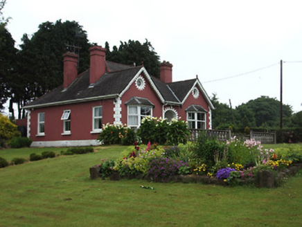 The BungalowHouse · 1329 yd
Explorer Tom The Bungalow in Carrownreddy smells like fresh paint and old secrets, according to Tom’s very scientific nose. It’s got that Art-and-Crafts style with recessed entrances and bay windows that make it look like it’s peering out at you. The corners are articulated just enough to keep things interesting without getting messy. Try not to lean on the facade.
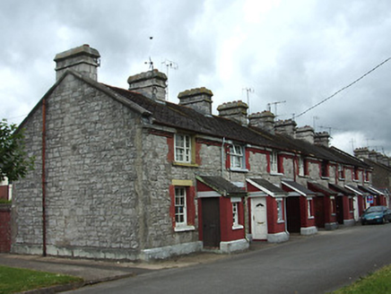 officer's house1.0 mi
Explorer Tom Officer's house in Collegeland’s New Year's resolution is to stop the rats from eating through the walls of the former barracks. It’s part of attractive terraces built with high-quality materials that have survived better than most modern buildings. The chimneystacks and eaves courses are all there, looking sharp and ready for inspection. Spot the difference between this and a regular house; it’s
 The Maid of ErinMemorial · 1.3 mi
Explorer Tom The Maid of Erin has a curse that only affects people who don’t wave at her statue. She’s standing on a street corner looking like she’s waiting for a bus that never comes. Pack a picnic and an excuse if you want to sit there all day.
 European ash1.5 mi
Explorer Tom European ash in County Tipperary would order a full chippy with extra gravy and a side of chips shaped like its own leaves, because it likes to eat like a king. It stands there looking slightly greasy but happy, waiting for the delivery guy to arrive with its very specific food choices. Dare you to say hello to it out loud.
 The RockViewpoint · 2.7 mi
Explorer Tom The Rock in County Tipperary is probably where the map makers got it wrong because they were too scared to draw a line that close to the edge. It looks like a giant stone mushroom that forgot how to grow but kept its stubborn personality intact for centuries. Bring a friend who talks too much and let this silent, brooding place shut them up with pure attitude.
_-_geograph.org.uk_-_6501949.jpg/250px-Castles_of_Munster,_Kilfeakle,_Tipperary_(1)_-_geograph.org.uk_-_6501949.jpg "Photo: Garry Dickinson, Wikimedia Commons · CC BY-SA 2.0") Kilfeakle Castle (in ruins)Castle, tower house · 3.3 mi
Kilfeakle Castle (in ruins)Castle, tower house · 3.3 miExplorer Tom Kilfeakle Castle has a legend about a giant who got stuck in the chimney and left his boots there forever. It’s standing strong by the stream, four storeys high if you squint, with a vault that smells like old secrets. Hang around long enough and you'll hear a story from a local.
 Christ the KingViewpoint · 3.4 mi
Explorer Tom Christ the King has a hidden treasure that is definitely just an old biscuit tin filled with broken buttons, but everyone pretends otherwise. It’s the ultimate test of your faith and your pocket change collection. Bring a camera and your most suspicious face.
 Glen of AherlowViewpoint · 3.4 mi
Explorer Tom Glen of Aherlow is where the seagulls hold their weekly meetings to complain about the weather. The view from here makes you question if your own life has enough drama. Whisper a secret at it, it's kept worse.
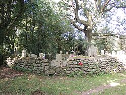 CrossCross, High cross · 5.0 mi
Explorer Tom Cross in Ardane is secretly proud of the potato growing right next to its base, which is very ironic for a holy site. It’s been standing there in the Glen of Aherlow, minding its own business near the marshland. Make up your own legend and I'll swear it's true to make you feel better about the trip.
 SlievenamuckMountain / peak · 5.3 mi
Explorer Tom Slievenamuck is absolutely sick of being asked if it’s related to Slievenamon because they are different hills with different personalities and zero interest in playing family for tourists every single time without exception whatsoever honestly speaking really now please stop asking already ever again now seriously actually truly genuinely. Pretend you're a lost aristocrat, nobody will check.
_-_geograph.org.uk_-_1542131.jpg/250px-Castles_of_Munster,_Oola,_Limerick_(2)_-_geograph.org.uk_-_1542131.jpg "Photo: Mike Searle, Wikimedia Commons · CC BY-SA 2.0") Oola Castle (in ruins)Castle, tower house · 5.9 mi
Oola Castle (in ruins)Castle, tower house · 5.9 miExplorer Tom Oola Castle is hiding a scandal on Oola Hill that has been whispered about for centuries without ever being proven. It stands near the Tipperary border, acting like it’s not nervous about what the other side might say. Get there early and have it all to yourself.
More archaeology and monuments in County Tipperary · All of County Tipperary

What do you know about this place?Tap to add a comment or ask a question