What is recorded here
Located on level ground at the E foothills of the Monavullagh Mountains. The old R C church of Kilrossanty (WA023-006001-) is within the rectangular graveyard (dims. c. 55m NW-SE; c. 50m NE-SW) attached to the present RC church. (Power 1937, 204)
Power, Rev. P. (1937) Waterford and Lismore; a compendious history of the united dioceses. Cork University Press.
From the National Monuments Service (Archaeological Survey of Ireland) record WA023-006002
The monument record does not grant public access. Check the route and ask the landowner before entering private land.
- What survives
- Recorded monument
Places near here
Photo credits
- National Inventory of Architectural Heritage
- kevin higgins, Geograph · CC BY-SA 2.0
- Rwxrwxrwx at English Wikipedia, Wikimedia Commons · Public domain
- Stephan van Helden, Wikimedia Commons · CC BY-SA 4.0
- John M, Geograph · CC BY-SA 2.0
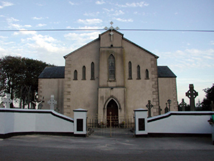 Saint Bridget's Catholic ChurchOfficially recorded historic building · 37 yd
 mill (water)200 ydHoly well in KilrossantyHoly well · 710 ydBawn in BarnankileBawn · 1239 ydBurnt mound in GortnalaghtBurnt mound · 1492 ydSite of CastleCastle, unclassified · 2.4 mi
 SeefinMountain / peak · 3.4 mi
 Mahon ValleyCliff · 3.7 mi
 Mahon FallsWaterfall · 3.9 mi
 KnockaunapeebraMountain / peak · 4.2 mi
 Horse-chestnut4.7 mi
 Stradbally CoveBeach / strand · 5.1 mi
More archaeology and monuments in County Waterford · All of County Waterford
What do you know about this place?