Places near here
Photo credits
- National Inventory of Architectural Heritage
- Kenneth Allen, Geograph · CC BY-SA 2.0
- M'Loughlin, Peter, Wikimedia Commons
- Kenneth Allen, Wikimedia Commons · CC BY-SA 2.0
- Alistair Cunningham, Wikimedia Commons · CC BY 3.0
- N Chadwick, Geograph · CC BY-SA 2.0
- Eeno11, Wikimedia Commons · CC BY-SA 3.0
- Sitomon, Wikimedia Commons · CC BY-SA 2.0
 bridge756 yd
Explorer Tom Bridge in Monfad is a single-arch giant that used to carry a 3ft narrow gauge railway. I reckon those little trains had to tiptoe across it like mice on a table, and now half the arch is just plugged up with bricks.
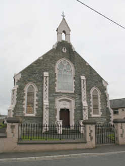 Newtowncunningham Presbyterian ChurchChurch/chapel · 1572 yd
Explorer Tom Newtowncunningham Presbyterian Church is the kind of place that brings its own dramatic lighting to any party. It’s got those cast-iron windows that look like they’re ready to sing a hymn, but probably just want some quiet. Give it a nod from the street and whisper that you know about its Gothic secrets.
 Coyles barPub · 1678 yd
Explorer Tom Coyles bar in County Donegal is probably hiding a secret stash of old pints behind the tap. I bet they serve a stout that tastes like it’s been marinating in peat for decades. Grab me a pint if you’re passing through!
_(page_1_crop).jpg/250px-Burt_Castle,_County_Donegal,_1833_(IA_jstor-30004355)_(page_1_crop).jpg "Photo: M'Loughlin, Peter, Wikimedia Commons") O'Doherty's CastleRuins · 2.6 mi
O'Doherty's CastleRuins · 2.6 miExplorer Tom O'Doherty's Castle near Burt is the one that can make a confident guide point towards Buncrana and get the wrong ruin entirely. This is Burt Castle, a sixteenth-century stronghold guarding the southern approach to Inishowen, with a plan influenced by Scottish fortification design. Sir Cahir O'Doherty used it as his headquarters during his 1608 revolt. I would offer to defend the approach, then remember the fort has been a ruin for a good while and put my imaginary helmet away. The story here involves real sieges and prisoners, so keep the account straight. Check lawful access before heading for the ruin and stay off unstable masonry. Stand where you can see the ground it guarded. The view explains the choice of site quicker than any boast from me.
 Burt CastleCastle, tower house · 2.6 mi
Explorer Tom Burt Castle's roofless keep still stands on the hill, with two round corner towers and rows of gun-loops. The old account even records a spiral stair with broken steps in the south-west tower. I would admire that stubborn stonework from safe ground; those steps sound like trouble.
 When Balor Came West: The Second Battle of Mag TuiredMythic battle remembrance · 3.3 mi
Explorer Tom When Balor Came West: The Second Battle of Mag Tuired sits on flat ground below Aileach, relying entirely on Eochu Ollathair’s poem rather than archaeology. I suppose it is easier to argue with a rhyme than a shovel.
 Rockfield Standing StoneStanding stone · 3.8 mi
Explorer Tom Rockfield Standing Stone is over two metres tall, but the picture says cows use it like a giant scratching post! I imagine them wiggling their noses against the rock to get a proper itch gone.
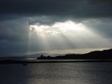 Inch Castle Promontory FortPromontory fort, coastal · 4.6 mi
Explorer Tom Inch Castle Promontory Fort sits right on Farland Bank, which is a bit of a mystery since the records are silent. But that coastal edge? I bet the wind there has been roaring since ancient times, keeping the ghosts perfectly chilled.
 Grianán of AileachHeritage attraction · 4.6 mi
Explorer Tom I offered to build this Donegal fort myself, then remembered I lack an army of stonemasons. Grianán of Aileach has a trick for anyone who thinks the round wall tells the whole story: it has passages inside the wall, and they stop short of the entrance as if the stone itself forgot where it was going. Climb your eyes up three interior terraces linked by steps, then look outside for the remains of a well and a tumulus. The place was a royal seat of Aileach, but the wall you see is largely a nineteenth century reconstruction. George Petrie surveyed a ruin in the 1830s; during the rebuilding of the 1870s, workers marked untouched masonry with tar so they could tell old work from new. That is a small, honest detail I like better than pretending every stone stayed put for a thousand years. Tradition says a Munster king mostly destroyed the fort in 1101; the exact surviving fabric needs the more careful story. This hill is exposed, and the terraces deserve steady feet. Donegal has built a crown you can walk around, so take a proper look before borrowing the view.
 Greenan MountainMountain / peak · 4.6 mi
Explorer Tom Greenan Mountain is a peak in County Donegal with no recorded access details. The picture looks north towards Inch Island, which makes me think the mountain is just using it as a background for its own very serious portrait.
 Rowan5.1 mi
Explorer Tom Rowan is in the middle of a fierce feud with the oak next door over who has the better view of the sunset. They’ve been arguing for decades about whose leaves are greener and whose branches sway more gracefully. It’s like watching two teenagers bicker, but slower and with more bark. Make up your own legend and I'll swear it's true.
 European Yew5.1 mi
Explorer Tom European Yew in County Donegal is a yew, which means it’s tough, old, and probably poisonous if you look at it wrong. It’s the kind of tree that survives empires and bad haircuts. Bring your own legend, I've run out, make up a story about a dragon living in its branches.
More archaeology and monuments in County Donegal · All of County Donegal

What do you know about this place?Tap to add a comment or ask a question