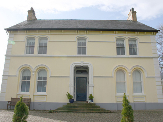
What is recorded here
Detached three-bay two-storey former Church of Ireland rectory, built c. 1870, with two-storey two-bay return to rear. Pitched slate roof, yellow brick chimneystacks with clay pots to gables, uPVC eaves and bargeboards, replacement rainwater goods over dentil eaves course. Painted rendered walls, render pilaster…
Read the whole record
From the Buildings of Ireland (National Inventory of Architectural Heritage) record 40905530
Places near here
Picture notes
- National Inventory of Architectural Heritage
- Computer-made picture. It does not show this monument.
- Computer-made picture. It does not show this mountain top.
- Computer-made picture. It does not show this playground.
- Kenneth Allen, Geograph · CC BY-SA 2.0
- Computer-made picture. It does not show this walking route.
- Kenneth Allen, Wikimedia Commons · CC BY-SA 2.0
- N Chadwick, Geograph · CC BY-SA 2.0
 mill (water)188 yd
Explorer Tom Mill in Tullyannan Glebe was built around 1860 for corn, with a waterwheel once fixed to its west side. The inventory records its cast-iron axle and later use as a hay shed. I can follow the change of jobs without asking that old wheel to spin again.
 Fairy fort / ringfort in Listicall LowerFairy fort / ringfort · 1525 ydComputer-made picture
Explorer Tom The Fairy fort / ringfort in Listicall Lower has been completely erased from the E slope, leaving just a memory of good land. It’s total map-ghost territory now, so if you’re feeling brave, maybe imagine what a farmer saw before the field swallowed it whole.
 Man-made underground passage in DooishMan-made underground passage · 1613 ydComputer-made picture
Explorer Tom Man-made underground passage in Dooish is one of several mysterious tunnels in this area, adding to the local lore. I imagine it was a bit like a giant’s basement, full of echoes and cool air. It’s a fun thought that someone dug their way through the rock just to create such a unique space.
 Tirroddy HouseHouse · 1.2 mi
Explorer Tom Tirroddy House was built around 1850 and later grew by two bays. At the entrance, plaster urns balance on the gate piers. I would have noticed the grand house eventually, but the little pots got to greet me first.
 Taylor's HillMountain / peak · 1.2 miComputer-made picture
Explorer Tom Taylor's Hill sounds like it belongs to a guy who never paid rent. He probably left it behind in a hurry and forgot about it entirely. Bring a friend who talks too much and let the place shut them up with its silence.
 Children's playground1.8 miComputer-made picture
Explorer Tom This Children's playground in County Donegal is a masterpiece of municipal boredom. But then a kid finds a stick and suddenly it is an epic quest. It is the kind of place that makes a dull Tuesday interesting.
 Coyles barPub · 1.8 mi
Explorer Tom Coyles bar in County Donegal is probably hiding a secret stash of old pints behind the tap. I bet they serve a stout that tastes like it’s been marinating in peat for decades. Grab me a pint if you’re passing through!
 Dooish MountainMountain / peak · 2.6 miComputer-made picture
Explorer Tom Dooish Mountain sits in County Donegal with its access details firmly locked away. The name has such a soft, rolling rhythm that I reckon it is probably just humming to itself while we all stand there, squinting at the blank map.
 Maylin WoodOfficial walking route · 2.7 miComputer-made picture
Explorer Tom Maylin Wood is a tiny loop that feels like a secret handshake with the trees. It's short enough for a quick wander or long enough to get lost in your own thoughts. Take a mate and argue about what it was for.
 Burt CastleCastle, tower house · 3.1 mi
Explorer Tom Burt Castle's roofless keep still stands on the hill, with two round corner towers and rows of gun-loops. The old account even records a spiral stair with broken steps in the south-west tower. I would admire that stubborn stonework from safe ground; those steps sound like trouble.
 When Balor Came West: The Second Battle of Mag TuiredMythic battle remembrance · 3.4 mi
Explorer Tom When Balor Came West: The Second Battle of Mag Tuired sits on flat ground below Aileach, relying entirely on Eochu Ollathair’s poem rather than archaeology. I suppose it is easier to argue with a rhyme than a shovel.
 Grianán of AileachHeritage attraction · 4.4 mi
Explorer Tom Grianán of Aileach makes a splendid lookout above Inishowen, with both Lough Foyle and Lough Swilly in sight. I would bring my questions about kings and legends up the hill, but I would sort out the practical matter first: Heritage Ireland says there are no toilets.
More historic places in County Donegal · All of County Donegal

What do you know about this place?Tap to add a comment or ask a question