
What is recorded here
From the National Monuments Service (Archaeological Survey of Ireland) record DG054-015
Places near here
Photo credits
- National Inventory of Architectural Heritage
- Maker not stated on source page, www.tripadvisor.com.ph
- Maker not stated on source page, tr.pinterest.com
- Maker not stated on source page, www.flickr.com
- Maker not stated on source page, www.dreamstime.com
- Maker not stated on source page, ph.pinterest.com
- Maker not stated on source page, www.kinopoisk.ru
- Kenneth Allen, Geograph · CC BY-SA 2.0
- Joe Boland / North West News Pix, via Donegal Daily, www.donegaldaily.com
 bridge418 yd
Explorer Tom Bridge in Dooish was built around 1820 with one rubble-stone arch over a small river. An 1837 map places flax and corn…
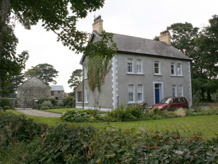 farm house1063 yd
Explorer Tom Farm house in Moneymore, built 1906, sports those yellow brick chimneys topped with polygonal clay pots. They look…
 Standing StonesMegalithic tomb · 1275 yd
Explorer Tom The Standing Stones at Dooish are just one gabled stone left standing on a ridge above Lough Swilly. Fagan saw two back…
 Standing stone in Dooish,listicall UpperStanding stone · 1621 yd
Explorer Tom Standing stone in Dooish is caught in a feud with the trigonometrical station it’s part of, arguing over who actually…
 Standing stone in CastleblaughStanding stone · 1651 yd
Explorer Tom Standing stone in Castleblaugh is officially no trace of the thing marked on old maps, sitting in a marshy low area…
 Standing stone in RyelandsStanding stone · 1.1 mi
Explorer Tom Standing stone in Ryelands is basically a ghost that got erased from its own photo! I bet it’s still up there on Dooish…
 Tullyannan GlebeRectory/glebe/vicarage/curate's house · 1.2 mi
Explorer Tom Tullyannan Glebe was already a glebe house in 1837, yet the current rectory only arrived around 1870. That thirty-year…
 mill (water)1.3 mi
Explorer Tom Mill in Tullyannan Glebe was built around 1860 for corn, with a waterwheel once fixed to its west side. The inventory…
 Standing stone in Tober (killea Ed)Standing stone · 1.4 mi
Explorer Tom Standing stone in Tober is officially gone, which feels like a prank. I keep imagining it just rolled down the SE slope…
 Maylin WoodOfficial walking route · 1.6 mi
Explorer Tom Maylin Wood is Donegal's reminder that a good outing does not need to occupy half a calendar. This small loop near…
 Coyles barPub · 1.8 mi
Explorer Tom Coyles bar in County Donegal is probably hiding a secret stash of old pints behind the tap. I bet they serve a stout…
 Páirc Cholm Cille, Naomh Colmcille GAA, NewtowncunninghamGAA ground · 2.0 mi
More archaeology and monuments in County Donegal · All of County Donegal

What do you know about this place?Tap to add a comment or ask a question