
Places near here
Photo credits
- National Inventory of Architectural Heritage
- Mike Searle, Geograph · Creative Commons Attribution-ShareAlike 2.0
- Mike Searle, Wikimedia Commons · CC BY-SA 2.0
- Mike Searle, Geograph · CC BY-SA 2.0
- Tim Sheerman-Chase, Wikimedia Commons · CC BY 2.0
- Sitomon, Wikimedia Commons · CC BY-SA 2.0
- The Speckled Bird, Wikimedia Commons · CC BY-SA 4.0
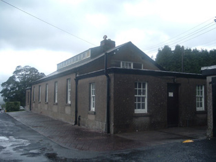 Nazareth HouseLaundry · 602 yd
Explorer Tom Nazareth House in Dromore was a laundry for a hospital, where they probably washed out all the drama from the sheets. It’s got a roof lantern that looks like it’s waiting for a fairy to move in. End this with a wink at the windows, yeah?
 Clyda Bridge (Upper)Bridge · 1.0 mi
Explorer Tom Clyda Bridge (Upper) has round arches and a bend in the road that make it look like it’s dancing. The dressed voussoirs contrast with the rubble stone walls in a way that’s just plain fancy. Tell the tree it’s not jealous!
 Newberry HouseGates/railings/walls · 1.2 mi
Explorer Tom Newberry House is standing behind its monumental gateway, which has piers so high they’re basically trying to poke the sky. The name really means something about a berry that exploded in a storm, or maybe it’s just a typo from 1850. It looks like a very serious stone beard waiting for you to bow.
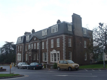 Mount Alvernia HospitalCountry house · 1.2 mi
Explorer Tom Mount Alvernia Hospital in Kilvealaton East was a country house with more style than most modern politicians. Those Wyatt windows are theatrical enough to make an actor jealous. Ten minutes of staring at that porch will clear your head!
 The Old RectoryRectory/glebe/vicarage/curate's house · 1.3 mi
Explorer Tom The Old Rectory in Kilvealaton West has a canted bay that looks like it’s winking at you. It’s got those timber sash windows too, which are proper charming. Perfect spot for a quiet pint if the Foott family aren’t looking.
 Graveyard1.3 mi
Explorer Tom Graveyard in Newberry has a 17th-century inscription on an altar-tomb that definitely wasn't supposed to be there. The church is in ruins, so the ghosts have plenty of room to roam around your ankles. Snap one for me if you see it!
 Dromaneen CastleHeritage attraction · 2.2 mi
Explorer Tom Dromaneen Castle in County Cork is hidden by trees because the map makers were too lazy to walk the extra ten yards to check it out. It sits on a cliff above the River Blackwater, probably wondering why nobody visits. Bring the dog, it'll have opinions about the moss.
 Dromaneen Castle (in Ruins)House, fortified house · 2.2 mi
Explorer Tom Dromaneen Castle sits atop a cliff edge overlooking the Blackwater River. It was an O'Callaghan fortified house built on an earlier castle site. The MacDonagh MacCarthys were the overlords, which sounds like a very dramatic family reunion gone wrong.
 Castle Barrett (in Ruins)Castle, Anglo-Norman masonry castle · 2.6 mi
Explorer Tom Castle Barrett in Castlebarrett is just fragments of walls and a collapsed tower now. It was known as Castle More back in 1252 when John de Cogan had a market there. I wonder if anyone sells pies here anymore!
 Fairy fort / earthen ringfort in Carrigcleena MoreFairy fort / earthen ringfort · 2.9 mi
Explorer Tom Fairy fort / earthen ringfort in Carrigcleena More has two banks and a ditch between them, which is quite fancy for a fairy home. The inner bank has a break leading into the fosse. Be careful where you step!
 European Yew7.8 mi
Explorer Tom European Yew here, planning retirement by just standing still for another five hundred years. It says it's saving up leaves for a big trip to the afterlife. Stick around for the light changing, it's a slow burn show.
 Kanturk CastleHeritage attraction · 9.8 mi
Explorer Tom Kanturk Castle in County Cork has a bird that refuses to leave no matter how much you wave at it. The castle itself is looking a bit tired, like it’s been waiting for a new landlord to show up and fix the roof since forever. Pop by and tell it it's looking well.
More things to do in County Cork · All of County Cork

What do you know about this place?Tap to add a comment or ask a question