Places near here
Photo credits
- Mike Searle, Geograph · CC BY-SA 2.0
- VisionsofthePast, Wikimedia Commons · CC BY-SA 4.0
- E Turk, Wikimedia Commons · CC BY-SA 4.0
- National Inventory of Architectural Heritage
- The Speckled Bird, Wikimedia Commons · CC BY-SA 4.0
- Colin Park, Wikimedia Commons · CC BY-SA 2.0
- Hywel Williams, Geograph · Creative Commons Attribution-ShareAlike 2.0
- CaitNi, Wikimedia Commons · CC BY-SA 4.0
 Dunmahon Castle (in Ruins)Bawn · 1368 yd
Explorer Tom Dunmahon Castle is hiding a scandal behind its low walls, probably about who ate the last pie in 1600. The tower's invisible from the road, which is annoyingly clever of it. Snap one photo, then actually look.
 LabbacalleeWedge tomb · 1384 yd
Explorer Tom Labbacallee is one of the largest wedge tombs in the country, sitting on a knoll near Funshion River. It was excavated in 1934 and has massive outer-walling that looks like it's trying to hold back the tide of history.
 Glanworth BridgeBridge · 1676 yd
Explorer Tom Glanworth Bridge spans the River Funshion with limestone arches that are three metres wide. That’s barely enough for a horse and cart, let alone your ego. A prophecy said it would sink in 2050; haven’t seen it yet.
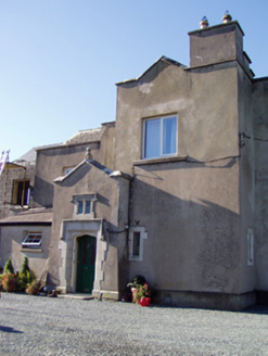 Ballyclogh HouseCountry house · 1700 yd
Explorer Tom Ballyclogh House in Ballyclogh is a remnant of a demolished country house. Built as a ballroom in 1904, it has Gothic Revival crenellations. It’s now a private house with Coade stone details. The pinnacles are still there to show off. Admire the facade!
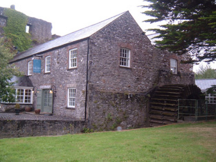 Glanworth MillMill (water) · 1732 yd
Explorer Tom Glanworth Mill is built right into the rock face, which is either brilliant or terrifying depending on how much you trust limestone. It’s got a waterwheel from the 1780s and sits below a medieval castle, so it’s basically living in the shadow of history while grinding flour.
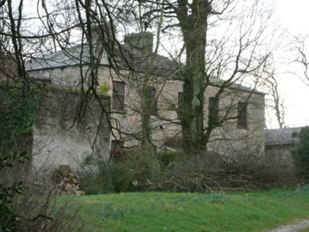 The RectoryRectory/glebe/vicarage/curate's house · 1.0 mi
Explorer Tom The Rectory in Glanworth is a commanding glebe house that probably judges your fashion choices from the window. It has timber sash windows and a slate roof, looking very Church of Ireland about it. Imagine Saint Patrick critiquing its interior design!
 Glanworth CastleCastle · 1.0 mi
Explorer Tom Glanworth Castle in County Cork is probably dreaming of being a grand mansion instead of just standing there looking slightly tired. It might have a hidden cellar full of old letters and gossip. Peek inside.
 Glanworth Castle (in Ruins)Castle, Anglo-Norman masonry castle · 1.0 mi
Explorer Tom Glanworth Castle in County Cork sits on a promontory with natural defences, but let's be honest, the nettles are doing more security work than any wall. Mind the nettles, they're the real guards here and they don't tip.
 The PresbyteryPresbytery/parochial/curate's house · 1.0 mi
Explorer Tom The Presbytery in Glanworth is a canted-bay house from 1880 that sits right next to the church. It’s got pointed arch gates and looks like it’s waiting for the vicar to come out with a glass of wine. It’s a proper groupie, really. Take a peek!
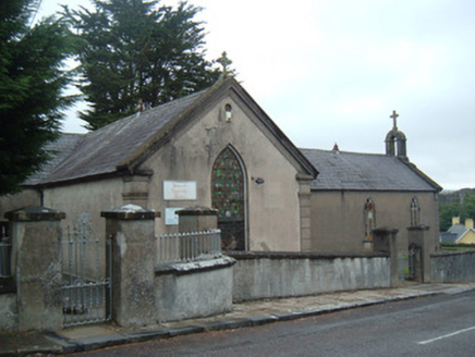 church/chapel1.0 mi
Explorer Tom Church or chapel in Glanworth has been turned into a community centre, which is like turning a church into a gym but with more soul. It was originally entered from the east gable, now it’s flipped around. It’s sitting on a hill peak, judging your spiritual fitness.
 St Bernards WellHoly well · 3.8 mi
Explorer Tom St Bernards Well in Duntahane was built by someone who thought two adjacent wells were enough, but really just created a concrete-lined water system for the River Blackwater to drink from. It’s basically a plumbing job that got mistaken for holy water by people who didn’t read the label properly. Best seen with a hangover and a sausage roll.
 CarrigeenamronetyMountain / peak · 8.9 mi
More archaeology and monuments in County Cork · All of County Cork

What do you know about this place?Tap to add a comment or ask a question