
What is recorded here
On the NW slope of Slievebawn. A possible cursus (L c. 270m) identified on OSI aerial (2005 ed.) consisting of two parallel banks or grass/heather/turf-covered walls (Wth 2-2.6m; H 0.2-0.8m) composed of schist and quartz (pers. comm. Ivor Kenny, 10 July 2014). The lower portion of the monument runs NW-SE for c. 160m…
Read the whole record
From the National Monuments Service (Archaeological Survey of Ireland) record CW020-026
Places near here
Photo credits
- Alex Passmore, Geograph · CC BY-SA 2.0
- Maker not stated on source page, commons.wikimedia.org
- National Inventory of Architectural Heritage
- liam murphy, Geograph · CC BY-SA 2.0
- Mike Searle, Wikimedia Commons · CC BY-SA 2.0
- liam murphy, Wikimedia Commons · CC BY-SA 2.0
- Maker not stated on source page, ru.pinterest.com
- liam murphy, Geograph · Creative Commons Attribution-ShareAlike 2.0
- Graham Horn, Wikimedia Commons · CC BY-SA 2.0
 SlievebawnMountain / peak · 243 yd
Explorer Tom Slievebawn in County Carlow hosted a fake royal visit in 1890 that nobody can disprove because everyone was drunk. The…
 Earthwork in KnockendraneEarthwork · 1.1 mi
Explorer Tom Earthwork in Knockendrane is a sixty-five-metre circle divided by a stone wall along the field boundaries. I bet it has…
 Mount Leinster LodgeCountry house · 1.1 mi
Explorer Tom Mount Leinster Lodge was designed by Daniel Robertson in 1840 and has an oriel window that looks like it’s peeking at…
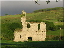 Bawn in RathnageeraghBawn · 1.2 mi
Explorer Tom The bawn at Rathnageeragh is just a slightly raised platform with a ditch, which is basically a garden that gave up on…
 Rathnageeragh Castle (in ruins)Castle, unclassified · 1.2 mi
Explorer Tom Rathnageeragh Castle has a gatehouse so square it looks like it was cut from a single block of stubborn stone. The…
 Burial GroundGraveyard · 1.6 mi
Explorer Tom Burial Ground in Seskinnamadra is oval-shaped with a church smack in the middle, which is either very practical or just…
 Catholic Chapel (in ruins), Stone CrossChurch · 1.7 mi
Explorer Tom Catholic Chapel, Stone Cross in Drumfea has granite rubble standing tall, looking very serious about its job. It’s a…
 Drumphea GraveyardGraveyard · 1.7 mi
Explorer Tom Drumphea Graveyard had its most dramatic moment when a pigeon landed on a headstone and nobody blinked for an hour.…
 Saint Laserian's Catholic ChurchChurch/chapel · 1.7 mi
Explorer Tom Saint Laserian's Catholic Church in Drumfea is a cruciform beauty with an Ionic reredos that looks like it belongs in a…
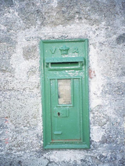 post box1.8 mi
Explorer Tom Post box in Drumfea is a cast-iron Victorian letter box from 1880 with a 'VR' monogram that stands for Victoria Regina…
 Standing stone in KilloughternaneStanding stone · 1.8 mi
Explorer Tom Standing stone in Killoughternane is propped up with a chocking stone, which is basically cheating at gravity. It looks…
 CroaghaunMountain / peak · 2.5 mi
Explorer Tom Croaghaun in County Carlow is the hill with a forest road to its summit, not the cliff-flinging giant on Achill Island…
More archaeology and monuments in County Carlow · All of County Carlow

What do you know about this place?Tap to add a comment or ask a question