What is recorded here
From OpenStreetMap (© OpenStreetMap contributors) w436854897
Places near here
Picture notes
- liam murphy, Geograph · Creative Commons Attribution-ShareAlike 2.0
- National Inventory of Architectural Heritage
- Mike Searle, Wikimedia Commons · CC BY-SA 2.0
- liam murphy, Geograph · CC BY-SA 2.0
- Maker named on the Wikimedia Commons picture page · CC BY-SA 2.5
- liam murphy, Wikimedia Commons · CC BY-SA 2.0
- Andreas F. Borchert, Wikimedia Commons · CC BY-SA 4.0
- Alex Passmore, Geograph · CC BY-SA 2.0
- Christian Pirkl, Wikimedia Commons · CC BY-SA 3.0 at
- Graham Horn, Wikimedia Commons · CC BY-SA 2.0
- Computer-made picture. It does not show this playground.
- A.-K. D., Wikimedia Commons · CC BY-SA 4.0
 Saint Laserian's Catholic ChurchChurch/chapel · 52 yd
Explorer Tom Peering at Saint Laserian's Catholic Church, I imagine the quiet dignity of its Ionic reredos standing proudly in Drumfea.
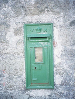 post box74 yd
Explorer Tom Drumfea’s post box displays a 'VR' monogram on its cast-iron surface, a Victorian letter box from circa 1880.
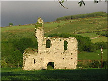
_-_geograph.org.uk_-_5029625.jpg/250px-Castles_of_Leinster,_Rathnageeragh,_Co._Carlow_(1)_-_geograph.org.uk_-_5029625.jpg "Photo: Mike Searle, Wikimedia Commons · CC BY-SA 2.0") Rathnageeragh Castle (in ruins)Castle, unclassified · 1235 yd
Rathnageeragh Castle (in ruins)Castle, unclassified · 1235 ydExplorer Tom Rathnageeragh Castle stands as a square gatehouse with a vaulted passageway, featuring surviving walls, a mural stair, and a garderobe chute.
 Bawn in RathnageeraghBawn · 1237 yd
Explorer Tom The Bawn in Rathnageeragh is a slightly raised platform extending from the castle block, defined by old fosse lines on its northern and eastern sides.
 Sessile Oak1.3 mi
Explorer Tom A Sessile Oak leans in slightly, curious about what we’re up to while it quietly holds the ground together.
 Burial GroundGraveyard · 1.4 mi
Explorer Tom This oval graveyard in Seskinnamadra has a church centrally located within it, making for a very symmetrical and sacred layout.
 Font in KilloughternaneFont · 1.8 mi
Explorer Tom Located outside the church, this granite font features a rectangular basin with a central outlet.
 SlievebawnMountain / peak · 1.9 mi
Explorer Tom Slievebawn looks out toward Blackstairs Mountain; it’s a peak in County Carlow with a name that feels like an old Irish lullaby.
 Sycamore2.8 mi
Explorer Tom This Sycamore sways gracefully, likely showing off its large, palm-like leaves to anyone who looks up in time.
 CroaghaunMountain / peak · 3.0 mi
Explorer Tom Croaghaun is a peak in County Carlow; views from Corrbut Gap suggest it's the last significant hill to the north, quite grand!
 Children's playground3.0 miComputer-made picture. It does not show this playground.
Explorer Tom A Children's playground in County Carlow, where I imagine tiny boots stomping enthusiastically on the fresh grass.
 The Columban WayVisitor information · 5.8 mi
Explorer Tom The Columban Way in Bagenalstown, County Carlow, marks a key point on this historic route through the Irish countryside.
More memorials and graveyards in County Carlow · All of County Carlow

What do you know about this place?Tap to add a comment or ask a question