Places near here
Photo credits
- National Inventory of Architectural Heritage
- Mike Searle, Geograph · CC BY-SA 2.0
- A.-K. D., Wikimedia Commons · CC BY-SA 4.0
- Brian Shaw, Wikimedia Commons · CC BY-SA 2.0
- Malene Thyssen, Wikimedia Commons · CC BY-SA 3.0
- No machine-readable author provided. MPF assumed (based on copyright claims)., Wikimedia Commons · CC BY 2.5
- Working Men's Educational Union, Wikimedia Commons · Public domain
- Eric Jones, Geograph · CC BY-SA 2.0
Explorer Tom All Saints' Well in County Offaly has an imaginary twin across the sea that keeps sending rude postcards. It’s just a spring, but it acts like it’s running a major international spa operation. The water is cold, the vibe is chaotic, and the legends are thinner than paper. Count the crows, then count again.
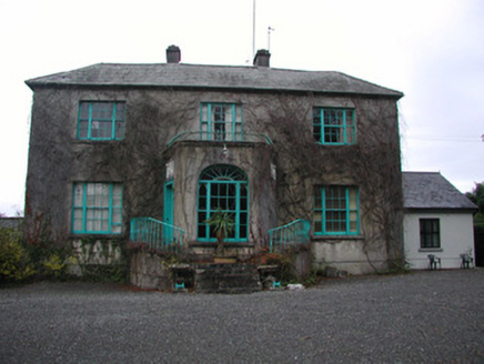 Claremount HouseCountry house · 1.3 mi
Explorer Tom Claremount House had a matchmaker who could pair you off in thirty seconds flat, guaranteed. The porch is surprisingly elaborate for a house that looks modest from the road. Have a sandwich here and wait for your soulmate to appear.
 Garry Castle in ruinsCastle, tower house · 1.3 mi
Explorer Tom Garry Castle in Garrycastle is a four-storey tower house that makes a spooky sound at night when the wind hits it. Only two walls are left standing, but they still look like they’re arguing with each other about who’s taller. It was built by a MacCoghlan in 1450, which means it’s older than most of your excuses for being late. Bring curiosity with you and leave with a better story than mine.
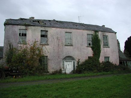 Castle Garden HouseCountry house · 1.6 mi
Explorer Tom Castle Garden House in Garrycastle is derelict now but was once a substantial country house with elegant sweeping entrance gates. The gates are still stylish even if the house behind them isn’t doing so well. Check it out from the outside, but don’t expect to find tea and biscuits inside the ruin.
Site of Feddaun CastleCastle, unclassified · 2.1 miExplorer Tom Site of Feddaun Castle is telling the bungalow built on top of it to shut up. The castle is ghosting everyone while pretending it never existed in the first place. Look for the ghost, then pretend you didn't.
 CrossCross, High cross · 2.5 mi
Explorer Tom Cross in Kylebeg is called 'Kylebeg,' which sounds like a sneeze and a bedsheet having an argument. It’s part of a church that’s had more renovations than my kitchen sink. The name probably means something profound, but I think it just means 'tired.' Pick a stone, any stone, and invent its biography.
 Banagher TowerMartello tower · 3.0 mi
Explorer Tom Banagher Tower in Esker is a Martello tower that looks like it’s waiting for the French to show up late. It’s got a job interview answer of 'I stand still.' Bring a pen pal, they'll be jealous you’re hanging out with history.
 European Beech4.1 mi
Explorer Tom European Beech in County Offaly is standing there with a scandal tucked away under its bark for centuries. It’s got that fancy European look, but I bet it’s been whispering secrets to every squirrel that climbs up it. The tree is probably judging your posture right now while it holds onto all those juicy little tidbits. If you want the full story, ring your granny and tell her where
 Common box4.2 mi
Explorer Tom The Common Box in County Offaly thinks Dublin tourists are noisy and badly dressed, which is fair. It’s small, dense, and judges your gardening skills without saying a word. Go on, count the windows on nearby houses and get it wrong like I did.
.jpg/250px-Lossy-page1-6940px-Lord_Rosse's_Great_Reflecting_Telescope,_at_Parsonstown,_Ireland_RMG_F8661_(cropped).jpg "Photo: Working Men's Educational Union, Wikimedia Commons · Public domain") The Great Telescope 'Leviathan'Heritage attraction · 4.4 mi
The Great Telescope 'Leviathan'Heritage attraction · 4.4 miExplorer Tom Birr built a telescope so big even my ego looks through the small end. The Leviathan at Birr Castle was not named for modesty. William Parsons finished this enormous telescope in 1845 with a mirror six feet across, and it remained the world's largest until 1917. That mirror weighed almost three tons. Worse for anyone hoping for an easy night's astronomy, its metal surface tarnished quickly, so Parsons made two mirrors and polished one while the other was in use. I would polish one mirror while you used the other, then ask how many years that takes. The great tube sat between high stone walls, with chains and weights to help move its twelve ton bulk. This is science with sleeves rolled up, steam machinery and a tremendous amount of patience. The telescope is within the Birr Castle estate visitor grounds, so check current admission and access before heading in. Stand beneath it and picture someone asking for a slightly bigger view of the sky, then actually building this answer.
 Birr Heritage CentreMuseum · 4.7 mi
Explorer Tom Birr Heritage Centre in County Offaly thinks tourists from Dublin are all talk and no history. It’s seen enough people claim to know everything about the local stars without reading a single plaque. It waits patiently for them to realize they missed the point entirely. Bring someone who'll believe anything.
 Cloghan HillMountain / peak · 5.9 mi
Explorer Tom Cloghan Hill in Offaly thinks all tourists from Dublin are just lost actors looking for their next big break. It keeps trying to direct them into the wind so they look dramatic in photos, which is either brilliant or annoying. The hill has strong opinions on your haircut and your life choices. Bring biscuits, every good story needs biscuits.
More historic places in County Offaly · All of County Offaly

What do you know about this place?Tap to add a comment or ask a question