Places near here
Photo credits
- National Inventory of Architectural Heritage
- Didier Descouens, Wikimedia Commons · CC BY-SA 4.0
- Pamela Norrington, Geograph · CC BY-SA 2.0
- Richard Webb, Geograph · CC BY-SA 2.0
- Alan Reid, Geograph · CC BY-SA 2.0
- Newbert12, Wikimedia Commons · CC BY-SA 4.0
- JohnArmagh, Wikimedia Commons · CC BY-SA 3.0
- Kay Atherton, Geograph · CC BY-SA 2.0
Explorer Tom Castle in Belclare has a fox that took full charge of the ruins last Tuesday. The ivy is winning the battle against gravity one leaf at a time. Linger, it's not going anywhere and neither should you.
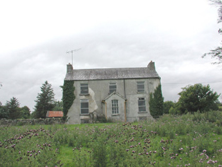 The GlebeRectory/glebe/vicarage/curate's house · 1275 yd
Explorer Tom The Glebe in Kilmacteige has been hiding a scandal for centuries, probably involving a vicar who fell in love with the church cat and then ran off to Dublin. It’s isolated and derelict but still sitting there comfortably in the landscape, with those early sash windows looking like they’ve seen it all. Just appreciate the rural setting without getting any ideas.
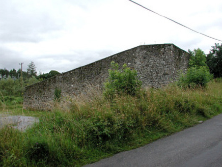 handball alley1471 yd
Explorer Tom Handball alley in Kilmacteige would say in a job interview 'I have excellent reflexes but terrible social skills' because it’s just walls for hitting things against them. It’s well-built rubble stone that’s becoming rare, so it’s basically a dinosaur of the countryside. Check out those substantial walls from outside!
 Hawthorn3.8 mi
Explorer Tom Hawthorn nearly got famous when a tourist mistook its white flowers for a very aggressive snowstorm and ran away screaming. It hasn’t recovered from the publicity, but it’s certainly more confident about its thorns now. Stick around for the light changing, it's a show.
Castle Carragh in RuinsCastle, unclassified · 3.9 miExplorer Tom Castle Carragh in Ruins is an L-shaped foundation that looks like it was eaten by a very large, lazy dog. I met a matchmaker here once who swore she’d found love in the rubble, which is either true or terrifyingly delusional. Mind the nettles, they're the real guards here.
KnockasliggaunMountain / peak · 4.3 miExplorer Tom Knockasliggaun in County Sligo started because two lads bet a fiver that they could name a hill after nothing. They lost, but the name stuck, which is somehow worse. A proper spot for a flask of tea and a big think.
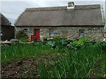 Hennigan's Heritage CentreHeritage attraction · 4.5 mi
Explorer Tom Hennigan's Heritage Centre would cope brilliantly on a reality show, probably winning every challenge by sheer stubbornness and local knowledge. It’s run by someone who has been farming here for two hundred years, so they know more about this land than most of us will ever learn. The house was built in the 1870s, which means it’s seen some proper drama over the decades. Have a sandwich here and it
 Lough Talt TrailVisitor information · 4.6 mi
Explorer Tom Lough Talt Trail has a shortcut that is technically longer if you count the time spent arguing about which way is down. The water supply up there is public, but the ego of this trail seems to be private property. Get there early and have it all to yourself.
 Largan HillMountain / peak · 5.4 mi
Explorer Tom Largan Hill in County Sligo is strictly run by a terrier who barks at any cloud that passes overhead. The forest below looks young and confused, probably from all the shouting. Perfect detour when the satnav has a meltdown.
 IndicatedWedge tomb · 6.6 mi
Explorer Tom Wedge tomb in Carrowcrom is named after lovers but looks more like a bed where nobody wants to sleep. It’s got a name that sounds romantic but feels a bit dusty and lonely. Go before the tourists find out.
 Round Tower8.3 mi
Explorer Tom Round Tower in Meelick is sick of being asked if it’s actually round, because yes, mate, it’s circular, stop squinting at it from a distance. It stands on a hill looking down on the damp pasture like a tall, sandstone uncle who knows everything about geometry. Bring your nan, she'll know more than me.
 Lough CullinViewpoint · 10 mi
Explorer Tom Lough Cullin again? Apparently there are two of them, which is either impressive or lazy. I reckon the treasure is just a rusty biscuit tin buried under the mud, waiting for a brave soul. The Nephins in the distance are judging us, but we don’t care. Mind the nettles, they're the real guards here.
More archaeology and monuments in County Sligo · All of County Sligo

What do you know about this place?Tap to add a comment or ask a question