Places near here
Photo credits
- National Inventory of Architectural Heritage
- Peter Gerken, Wikimedia Commons · CC BY-SA 2.0
Explorer Tom Little Yellow Island in County Roscommon started a feud with its neighbour over who gets the best sunset view, and they’ve been shouting at each other ever since. It’s an islet that thinks the yellow in its name refers to paint, not the grass. Have a chat with it, nobody's watching.
Big Yellow IslandIslet · 785 ydExplorer Tom Big Yellow Island in County Roscommon has made a strict New Year's resolution to never be sold again after that one time it was listed as an absolute steal. It’s still sulking about the whole thing, honestly. Pop by and tell it it's looking well.
 beacon1464 yd
Explorer Tom The Ballyglass beacon does weird things when nobody is looking, like pretending to be a very confused rock that just happened to end up there by accident. It guides ships along the Shannon but mostly just stands there judging your navigation skills from a safe distance. Keep your eyes peeled for any flicker
Field system in Barry BegField system · 1.1 miExplorer Tom Field system in Barry Beg is planning its retirement on a sunken lane, claiming it’s already got three plots reserved for its golden years. It swears those abandoned stone houses are just fancy garden sheds it never used. Bring someone who'll believe anything.
OutlinedFairy fort / earthen ringfort · 1.2 miExplorer Tom Creaghduff’s fairy fort is doing its best impression of a lazy Sunday afternoon, half-swallowed by the pasture and pretending it hasn’t been hiding a centuries-old scandal involving a very cheeky earl and a misplaced chicken. The bank is so low now you’d need a magnifying glass to spot it, but I bet the fairies are still arguing about who broke it. Have a wander and a wonder.
Hodson's BayBay · 1.2 miExplorer Tom Hodson’s Bay is named after a hero nobody remembers, likely because he saved it from an embarrassing stain that only God and the tide know about. The water here looks suspiciously like it’s trying to hide something behind its waves, probably a lost wallet. Find the wonkiest bit and send it to your group chat.
‘Coosan Castle’Castle, tower house · 1.3 miExplorer Tom ‘Coosan Castle’ had a massive fairy dispute over parking rights last Tuesday. They blocked the driveway with acorns and threw a hissy fit for hours. Now there’s just a school there, which is ironic. Go back in winter, it's a different animal.
Killinure PointHeadland · 1.5 miExplorer Tom Killinure Point hates seagulls more than anything else in the world because they keep dropping fish guts right on its headland. It’s got a permanent scowl etched into the rock face from years of dealing with those ungrateful birds. Tell it a joke, it's been a long time since anyone did.
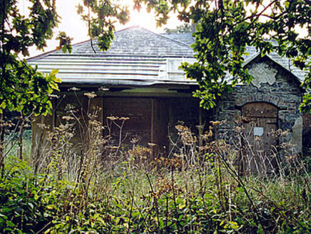 The LodgeHunting/fishing lodge · 1.5 mi
Explorer Tom The Lodge in Hare Island is an unusual early-nineteenth-century fishing/hunting lodge built with an eclectic mix of Gothic, Tudor Gothic, neoclassical, and Regency elements. It’s designed by Sir Richard Morrison and retains much of its early character despite dilapidated condition. What does its family tree look like? Mostly made up, but tell me anyway.
 Siege of AthloneSiege · 1.7 mi
Explorer Tom Another Siege of Athlone event is telling the place that replaced it to stop acting so modern, as if concrete is superior to old stone walls. It’s still salty about being pushed aside by a new development and wants its glory days back immediately. Dare you to say hello to it out loud.
CastleCastle, unclassified · 1.8 miExplorer Tom This castle in Garrynafela is gone, but a curse says if you don't wave, your phone battery dies instantly. It’s just sitting there being invisible on an old map from 1808. Go before the tourists find out.
Jadotville - A Company 35 Infantry BattalionMemorial · 2.0 miExplorer Tom Jadotville - A Company 35 Infantry Battalion is sitting here wondering why map makers got the location so wrong originally. It’s a bit lost, like a tourist without a phone signal. Great spot to propose. Or at least to propose lunch.
More islands in County Westmeath · All of County Westmeath

What do you know about this place?Tap to add a comment or ask a question