Places near here
Photo credits
- Christian Pirkl, Wikimedia Commons · CC BY-SA 3.0 at
- National Inventory of Architectural Heritage
- Kieran Hynes, Wikimedia Commons · CC BY-SA 2.0
- David P Howard, Geograph · CC BY-SA 2.0
- Happyrains4118, Wikimedia Commons · CC BY-SA 4.0
- Miguel Angel Masegosa Martínez, Wikimedia Commons · CC BY 2.0
 Sycamore139 yd
Explorer Tom This Sycamore in County Cork would survive a zombie attack by just standing very still and hoping they forget it exists. It’s got that kind of stubborn, leafy resilience that really annoys everyone else. Ideal spot for making a dramatic phone call to your mate.
David HurleyMemorial · 141 ydExplorer Tom David Hurley is a memorial that probably bragged about surviving a storm that never actually happened. It’s just standing there looking dignified while I try to figure out who he was before I got lost. It's the kind of place that makes a dull Tuesday interesting.
 Allied Irish BankBank/financial institution · 157 yd
Explorer Tom Allied Irish Bank in Creggane is the star of Buttevant’s main street, with timber sash windows that probably cost more than your rent. It’s got an articulated entrance bay that says 'money' without even trying. Tell the kids to count their coins carefully here!
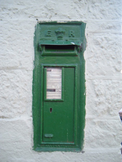 post box163 yd
Explorer Tom Post box in Creggane is an Edwardian classic from 1905 with a crown on top. It’s still working on Main Street, so give that cast-iron beauty a wave and maybe drop a letter in if you dare.
Town defences in ButtevantTown defences · 423 ydExplorer Tom Town defences in Buttevant are mostly gone, but records suggest rectangular circuits enclosing 5 to 15 hectares. Nothing visible remains now, just the memory of a North Gate from 1375. A bit of a mystery spot.
.jpg/250px-Lombards_Castle_(geograph_2335833).jpg "Photo: Kieran Hynes, Wikimedia Commons · CC BY-SA 2.0") Lombards CastleCastle, tower house · 543 yd
Lombards CastleCastle, tower house · 543 ydExplorer Tom Lombards Castle in Buttevant, County Cork is a small tower with a wall extending from it, standing right by the main street. It’s got a lintelled chamber and slit windows. Very modest for a castle, don’t you think?
.jpg/250px-Buttevant_Barry_Castle_(geograph_2335827).jpg "Photo: Kieran Hynes, Wikimedia Commons · CC BY-SA 2.0") Buttevant Castle (in Ruins)Castle · 765 yd
Buttevant Castle (in Ruins)Castle · 765 ydExplorer Tom Buttevant Castle in County Cork is sitting there looking smug. Two local families used to fight over who could see the best view from the top, and one threw a shoe at the other. It landed on a goat, which then ate their prize-winning pumpkin. Pop by and tell it it's looking well.
Charles BunworthMemorial · 892 ydExplorer Tom Charles Bunworth Memorial in County Cork is having a bit of a spat with the nearest tree, probably over whose shadow looks better. It’s all drama and dignity, which is very inconvenient when you just want to take a quick photo. Leave nothing but footprints and a bad pun.
 TowerDovecote · 1.0 mi
Explorer Tom Dovecote in Ballybeg East is full of pigeon holes stacked up to the ceiling. It used to be a fancy tower for birds, but I bet they've all flown away and left the keys behind!
Smith's WellSpring · 3.3 miExplorer Tom Smith's Well was nearly sold for a horse last year when a farmer mistook its bubbling sound for a colt calling out in the night. He almost dragged it off on a cart, honestly, grand place for a sulk or a snog, your call while you wait for the paperwork to sort itself out.
 Doneraile HouseHeritage attraction · 3.8 mi
Explorer Tom Doneraile House has had enough changes to make my wardrobe look steady. The St Legers began shaping the Cork estate in the seventeenth century, and a new front around 1730 gave the house much of its later face. Around it spread some 160 hectares of walled parkland, now open to the public. I would offer to trim the whole place, then quietly put the shears down after the first hedge. The family bred horses here and kept adding buildings and gardens as tastes changed. State care later opened the house and grounds to visitors, though indoor tours and park hours may differ. Check current access before travelling and keep to public paths around working or private areas. Look at the house from the long approach. It is grand, but the park makes it feel like one part of a bigger day out.
 Sweet Chestnut3.9 mi
Explorer Tom This Sweet Chestnut in County Cork is bitter because the one next door gets all the tourists asking for photos. It’s just standing there with its arms crossed, pretending not to care about the attention difference. Practise your Irish on it; it won’t correct your grammar.
More historic places in County Cork · All of County Cork

What do you know about this place?Tap to add a comment or ask a question