What is recorded here
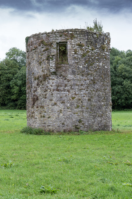
In flat pasture, to the SE of Ballybeg Augustinian Priory church. This circular columbarium (CO017-059003-; int. diam. 4.6m) is entered via a ground-floor door on the W side. The Interior wall face has continuous rows of nesting boxes (Wth 0.22m; H 0.2m; 32 boxes in each circuit), in 11 tiers up to a height of c. 5m (see plan and section in Brash 1852b, 266-7). Above this, the wall inclines gently inward for a height of c. 2m, above which it is corbelled in steeply, leaving a circular opening at the top. High up on the exterior wall face on the N side is a lintelled door giving access to mural stairs leading to the top of the tower, possibly to a wall-walk. Section of projecting masonry to the E of the door indicates the wall extending N from the columbarium, probably with a wall-walk, from which the door was accessed. This is a National Monument in State Guardianship (no. 301). Photographs attached:
CO017-059003-_01: View of columbarium from NW. CO017-059003-_02: Interior of columbarium, from W. CO017-059003-_03: View of from W, with ground-floor door. CO017-059003-_04: View from N, with lintelled door at top of tower. CO017-059003-_05: View from SE, with priory in the background.
In flat pasture, to the SE of Ballybeg Augustinian Priory church. This circular columbarium (CO017-059003-; int. diam. 4.6m) is entered via a ground-floor door on the W side. The Interior wall face has continuous rows of nesting boxes (Wth 0.22m; H 0.2m; 32 boxes in each circuit), in 11 tiers up to a height of c. 5m (see plan and section in Brash 1852b, 266-7). Above this, the wall inclines gently inward for a…
From the National Monuments Service (Archaeological Survey of Ireland) record CO017-059003
The monument record does not grant public access. Check the route and ask the landowner before entering private land.
- What survives
- Recorded monument
Places near here
 Ballybeg Abbey (in Ruins)Religious house, Augustinian canons · 55 ydEarthwork in Ballybeg EastEarthwork · 188 yd
 Clapper BridgeFoot bridge · 589 ydFish-pond in Ballybeg EastFish-pond · 591 ydCharles BunworthMemorial · 923 yd
 Sycamore1.0 miDavid HurleyMemorial · 1.0 mi
 Kilmaclenine CastleCastle · 2.6 mi
.jpg/250px-Castles_of_Munster-_Lisgriffin,_Cork_(geograph_3036422).jpg "Photo: Mike Searle, Wikimedia Commons · CC BY-SA 2.0") Lisgriffin CastleCastle · 3.5 mi
Lisgriffin CastleCastle · 3.5 mi Doneraile CourtFarmyard complex · 3.6 mi
 Doneraile CourtBuilding misc · 3.6 mi
 European Yew3.7 mi
Pictures: Andreas F. Borchert, Wikimedia Commons · CC BY-SA 4.0; Kieran Hynes, Geograph · CC BY-SA 2.0; Christian Pirkl, Wikimedia Commons · CC BY-SA 3.0 at; Mike Searle, Geograph · CC BY-SA 2.0; Mike Searle, Wikimedia Commons · CC BY-SA 2.0; National Inventory of Architectural Heritage; Sitomon, Wikimedia Commons · CC BY-SA 2.0
More archaeology and monuments in County Cork · All of County Cork
What do you know about this place?