DDiscover AloneMapAbout

Browne & Sons

House
Browne & Sons
Photo: National Inventory of Architectural Heritage · Report the wrong picture

This does not grant access. Most recorded buildings are privately owned; view them only from public ground unless the owner allows entry.

What do you know about this place?Tap to add a comment or ask a question

What you write will be public.

What is recorded here

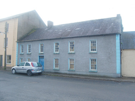
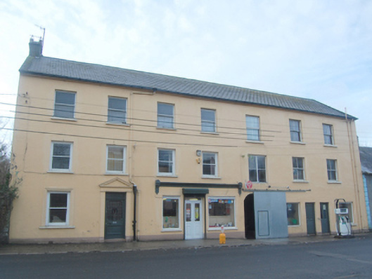
End-of-terrace seven-bay three-storey terrace of three buildings, built c. 1870, comprising two-bay two-storey house to the south end, central two-bay two-storey former house having shopfront, c. 1900, and with three-bay three-storey building to the north end having two shopfronts, c. 1940, and with integral…

Read the whole record
End-of-terrace seven-bay three-storey terrace of three buildings, built c. 1870, comprising two-bay two-storey house to the south end, central two-bay two-storey former house having shopfront, c. 1900, and with three-bay three-storey building to the north end having two shopfronts, c. 1940, and with integral carriage-arch to the south end. Now in use as accommodation, shops and petrol station. Pitched artificial slate roof with projecting eaves course, some surviving sections of cast-iron rainwater goods, with cast-iron and replacement rainwater goods, and with single smooth rendered chimneystack to the south gable end. Smooth rendered walls over projecting smooth rendered plinth course. Square-headed window openings to upper floors and to the south end at ground floor level having one-over-one (to buildings to south end and centre) and two-over-two-pane timber sliding sash windows (to building to the north); moulded stucco architraved surround to window opening to the south end at ground floor level. Square-headed window openings to shopfronts having fixed-pane display windows. Cast-iron ventilation vent over window openings to shopfront to central building. Square-headed doorways to shopfronts having replacement windows. Square-headed doorway to the building to the south having replacement timber door with leaded upper panel, flanking smooth rendered pilasters, and with stucco pediment over. Sliding metal door to segmental-headed carriage-arch. Stucco shopfront to central building having moulded rendered cornice terminated to either end by stucco console brackets. Road-fronted to the south end of Manorcunningham. Yard to rear with single-storey outbuildings to site.
This substantial terrace of mid-to-late nineteenth-century three-storey buildings dominates the streetscape of Manorcunningham, rising above the other two-storey and single-storey structures aligned along the main street. This terrace retains its original form, despite some alterations while its scale is unusual in a small village like Manorcunningham. The visual expression of this terrace is enhanced by the retention of the majority of the early timber sliding sash windows while modest decorative interest is added by the pedimented doorcase to the south end, the single architraved surround to the window opening to the south end at ground floor level, and by the stucco shopfront to the central building. The attractive cast-iron vents over the window openings to the central building are another interesting feature; these suggest that the central building may have formerly had a butcher’s premises as these are features found on many early shops of this type. It was formerly known as ‘Lindsays Building’ but it may have been originally built by the Doherty family who ran a number of commercial buildings in Manorcunningham in 1881 (Slater’s Directory). This plain but substantial terrace makes a positive contribution to the streetscape of Manorcunningham, and is an addition to the built heritage of the town.

From the Buildings of Ireland (National Inventory of Architectural Heritage) record 40827002

Places near here

Picture notes
  • National Inventory of Architectural Heritage
  • Computer-made picture. It does not show this monument.
  • Computer-made picture. It does not show this playground.
  • Computer-made picture. It does not show this mountain top.
  • Sitomon, Wikimedia Commons · CC BY-SA 2.0
  • Eeno11, Wikimedia Commons · CC BY-SA 3.0
  • Computer-made picture. It does not show this walking route.
  • Richard Webb, Wikimedia Commons · CC BY-SA 2.0
Ric barracks22 yd

Explorer Tom RIC barracks in Manorcunningham had Francis Sherridan as constable in 1881. Its two red brick chimneys look as if they were posted at opposite ends of a long shift and have refused to swap places ever since.

school39 yd

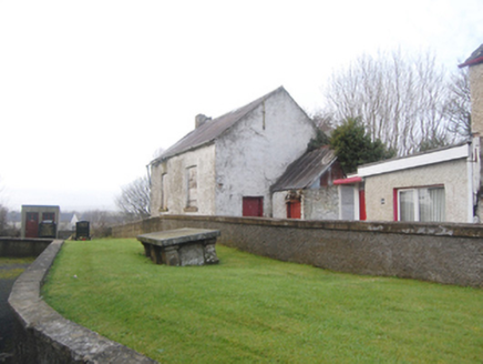
Explorer Tom School in Manorcunningham is a modest rubble stone building that’s been sitting there since the days of national schools, next to Raymochy Church. It’s robust and out of use, but it’s got some serious local social history baked into its walls.

Standing stone in ManorcunninghamStanding stone · 195 ydComputer-made picture

Explorer Tom Standing stone in Manorcunningham is officially gone, taken away back in 1979! It used to stand on a low rise near Lough Swilly. I bet it got bored of the view and packed its bags.

Children's playground275 ydComputer-made picture

Explorer Tom This Children's playground in County Donegal has swings that go higher than your confidence on a first date. The air smells like fresh grass and potential disaster. Look up, the best bit is always higher than you think.

Standing stone in RaymoghyStanding stone · 735 ydComputer-made picture

Explorer Tom Standing stone in Raymoghy has completely vanished from the hillside! The maps still show it, but my eyes see only grass. I bet it slipped its shoes and quietly walked away to find a quieter spot.

DrumoghillMountain / peak · 1.9 miComputer-made picture

Explorer Tom Drumoghill sits in County Donegal as a mountain peak with its access details firmly unknown to the mapmakers. It sounds like it is politely refusing to share a path, leaving you to wonder if the hill is just hiding behind an imaginary hedge.

European Yew2.6 mi

Explorer Tom European Yew in County Donegal is a yew, which means it’s tough, old, and probably poisonous if you look at it wrong. It’s the kind of tree that survives empires and bad haircuts. Bring your own legend, I've run out, make up a story about a dragon living in its branches.

Rowan2.6 mi

Explorer Tom Rowan in County Donegal is hiding because it thinks it wards off witches, but I'm pretty sure it just hates the rain. It needs permission to exist properly. Ask it politely if it wants a cup of tea.

Maylin WoodOfficial walking route · 2.8 miComputer-made picture

Explorer Tom Maylin Wood is a tiny loop that feels like a secret handshake with the trees. It's short enough for a quick wander or long enough to get lost in your own thoughts. Take a mate and argue about what it was for.

Battlefield in Tully (kincraigy Ed),glenmaquin Lower,roosky (castleforward Ed)Battlefield · 3.1 mi

Explorer Tom Battlefield in Tully, Glenmaquin Lower, Roosky is a patch of earth that remembers being trampled by very angry people. It's quiet now, but the ground still feels like it's holding its breath. Stand where the owner stood and practise looking smug about your discovery.

Dooish MountainMountain / peak · 3.6 miComputer-made picture

Explorer Tom Dooish Mountain sits in County Donegal with its access details firmly locked away. The name has such a soft, rolling rhythm that I reckon it is probably just humming to itself while we all stand there, squinting at the blank map.

Battle of GlenmaquinBattle · 3.7 mi

Explorer Tom The seagulls at Glenmaquin say the Battle of 1642 was mostly about who got the best sandwich first. Very political, very messy. Toast it with a cup of tea and move on to the next spot before you start overthinking the whole thing.

More historic places in County Donegal · All of County Donegal

Add to this placeAdd a picture Add a detailed tip Add a story

Explore the map1,093,392 places to discover

Next place · or swipeRic barracks