Places near here
Photo credits
- Kenneth Allen, Geograph · Creative Commons Attribution-ShareAlike 2.0
- National Inventory of Architectural Heritage
- Sitomon, Wikimedia Commons · CC BY-SA 2.0
- Eeno11, Wikimedia Commons · CC BY-SA 3.0
- danny kearney, Geograph · CC BY-SA 2.0
- Kenneth Allen, Wikimedia Commons · CC BY-SA 2.0
- Kenneth Allen, Geograph · CC BY-SA 2.0
- Steven Brown, Geograph · CC BY-SA 2.0
- Ian S, Geograph · CC BY-SA 2.0
- M'Loughlin, Peter, Wikimedia Commons
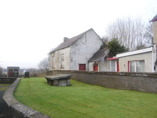
 Raymochy Church of Ireland Parish ChurchChurch/chapel · 29 yd
Explorer Tom Raymochy Church of Ireland Parish Church was built in 1792 and looks like a proper little castle that decided to keep its tower. The crenellated parapet with those pyramidal copings on the corners is such a cheeky touch for a parish church that’s also got a graveyard full of 19th-century history. It’s a great place to imagine all the secret plans the masons must have had for that stocky tower.
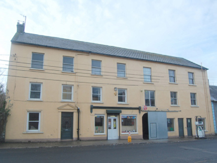 Browne & SonsHouse · 39 yd
Explorer Tom Browne & Sons has a sneaky little tunnel built right into its side! Built around 1870, I wonder if that arch was for a very chatty horse or just a stubborn cart. Did the carriages ever get stuck in there arguing?
 European Yew2.6 mi
Explorer Tom European Yew in County Donegal is a yew, which means it’s tough, old, and probably poisonous if you look at it wrong. It’s the kind of tree that survives empires and bad haircuts. Bring your own legend, I've run out, make up a story about a dragon living in its branches.
 Rowan2.6 mi
Explorer Tom Rowan is in the middle of a fierce feud with the oak next door over who has the better view of the sunset. They’ve been arguing for decades about whose leaves are greener and whose branches sway more gracefully. It’s like watching two teenagers bicker, but slower and with more bark. Make up your own legend and I'll swear it's true.
 Dry Arch MonumentHeritage attraction · 3.0 mi
Explorer Tom The Dry Arch Monument is a stainless steel flex for workers who probably just wanted a decent cup of tea and a break. The poet who fell in the ditch nearby wrote about 'architectural integrity' until he hit his head on the concrete edge. Bring a camera and your most suspicious face.
 Battle of FarsetmoreBattle · 3.0 mi
Explorer Tom Battle of Farsetmore in County Donegal is where Hugh O'Donnell kicked Shane O'Neill's backside into the River Swilly. Rumour has it a local goat watched from a cliff, heartbroken her mate picked a fight instead of romance. Give it a pat on the way past, it's had a long life.
Battlefield in Ballyboe Lisenan,ballyraine,farsetmore,gortlee,kiltoy,magheranan,glebe (castlewray Ed)Battlefield · 3.0 miExplorer Tom Battlefield in Ballyboe Lisenan claims a fake king visited to inspect the troops but got lost in the mud and never came back. Nobody can disprove it because the man was wearing a disguise and had terrible luck with his boots that day. Pick a stone, any stone, and invent its biography.
 The Clanree HotelHotel · 3.1 mi
Explorer Tom The Clanree Hotel sits along the N14 Bonagee Road, about two klicks east of Letterkenny, sounding like a family reunion that went wrong. Check if there’s a sign saying 'No Nephews Allowed' just for giggles. If it rains, blame me.
 Mount Errigal HotelHotel · 3.6 mi
Explorer Tom Mount Errigal Hotel sits on a mountain pretending to be humble. Three stars? I'd give it four just for the view of me being stuck up there! Pick a stone, any stone, and invent its biography.
 PoleStar MonumentHeritage attraction · 3.7 mi
Explorer Tom PoleStar Monument is standing tall in Letterkenny, looking like it knows exactly where north is even when the clouds are playing hide-and-seek with the sun. Saint Patrick would probably have told it to stop showing off and just get on with blessing the crops already, but it wouldn’t listen. Bring a flask and pretend you own the place.
 Mongorry HillMountain / peak · 4.1 mi
Explorer Tom Mongorry Hill swears by a superstition that says if you sneeze, you must buy a pint or it will rain all week. Locals are terrified of this rule, so they carry umbrellas even in sunshine just to be safe. Whisper a secret at it, because it has kept worse ones for centuries.
_(page_1_crop).jpg/250px-Burt_Castle,_County_Donegal,_1833_(IA_jstor-30004355)_(page_1_crop).jpg "Photo: M'Loughlin, Peter, Wikimedia Commons") O'Doherty's CastleRuins · 6.6 mi
O'Doherty's CastleRuins · 6.6 miExplorer Tom O'Doherty's Castle near Burt is the one that can make a confident guide point towards Buncrana and get the wrong ruin entirely. This is Burt Castle, a sixteenth-century stronghold guarding the southern approach to Inishowen, with a plan influenced by Scottish fortification design. Sir Cahir O'Doherty used it as his headquarters during his 1608 revolt. I would offer to defend the approach, then remember the fort has been a ruin for a good while and put my imaginary helmet away. The story here involves real sieges and prisoners, so keep the account straight. Check lawful access before heading for the ruin and stay off unstable masonry. Stand where you can see the ground it guarded. The view explains the choice of site quicker than any boast from me.
More historic places in County Donegal · All of County Donegal

What do you know about this place?Tap to add a comment or ask a question