
Places near here
Photo credits
- National Inventory of Architectural Heritage
- David Mullen / John Quirke Photography, credited by Meath GAA, meath.gaa.ie
- Kmcnamee, Wikimedia Commons · CC BY-SA 4.0
- Didier Descouens, Wikimedia Commons · CC BY-SA 4.0
- RonanMcCormick, Wikimedia Commons · CC BY-SA 4.0
- Bob Embleton, Geograph · CC BY-SA 2.0
- Richard Webb, Geograph · CC BY-SA 2.0
- Bill Griffiths, Wikimedia Commons · CC BY-SA 2.0
- Haydn Hammerton, Wikimedia Commons · CC BY-SA 4.0
- John M, Wikimedia Commons · CC BY-SA 2.0
 Virginia Road Railway StationRailway station · 50 yd
Explorer Tom Virginia Road Railway Station was designed by a mother-in-law who insisted on limestone dressings because she wanted…
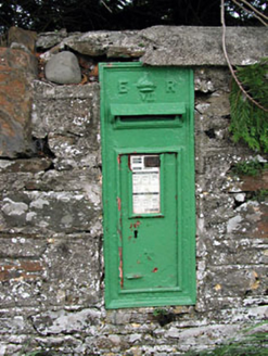 post box70 yd
Explorer Tom Post box in Pottlereagh is sitting there looking all smug and cast-irony. It's got that classic 'I was here before…
 Ballinlough GAAGAA ground · 2.6 mi
 Páirc Mhic Fhinn, Maghera MacFinn's GAAGAA ground · 2.7 mi
 Hawthorn2.8 mi
Explorer Tom Hawthorn in Meath has thorns sharp enough to survive any zombie attack without breaking a sweat. It’s the ultimate…
 CrossCross, High cross · 2.9 mi
Explorer Tom Cross in Castlekeeran is guarded by a dog who demands a biscuit before you even blink. The interlace is basically just…
 Grave YardGraveyard · 2.9 mi
Explorer Tom Graveyard in Castlekeeran would bring a Viking helmet to any party just to keep people on their toes. It’s seen looters…
 Earthen TumulusCastle, motte · 3.1 mi
Explorer Tom Earthen Tumulus in Patrickstown inspired a bad poem about a fairy queen who was actually just a very confused farmer.…
 IslandMountain / peak · 3.2 mi
Explorer Tom Island holds a fake world record for being the most confused geographical feature in all of County Cavan right now. It…
 Slieve Na CalliaghMountain / peak · 4.2 mi
Explorer Tom Slieve na Calliagh is Meath's highest hill at 276 metres, but its real claim is the crowd of ancient tombs along the…
 Loughcrew Megalithic TombsHeritage attraction · 4.2 mi
Explorer Tom You wanted one tomb? Loughcrew has sent you uphill for more than thirty. Loughcrew spreads its ancient monuments over…
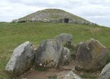 LoughcrewMegalithic tomb cemetery · 4.9 mi
Explorer Tom Loughcrew is a megalithic tomb cemetery on Slieve na Calliagh, which sounds like a place where the stones are just…
More historic places in County Meath · All of County Meath

What do you know about this place?Tap to add a comment or ask a question