
Places near here
Photo credits
- National Inventory of Architectural Heritage
- Mike Searle, Geograph · CC BY-SA 2.0
- David Purchase, Geograph · Creative Commons Attribution-ShareAlike 2.0
- Willow, Wikimedia Commons · CC BY 2.5
- Andreas F. Borchert, Wikimedia Commons · CC BY-SA 4.0
- Gillaween, Wikimedia Commons · CC BY-SA 4.0
- Sawyer777, Wikimedia Commons · CC BY-SA 4.0
- Enda O Flaherty, Geograph · CC BY-SA 2.0
- The original uploader was Dppowell at English Wikipedia ., Wikimedia Commons · CC BY-SA 2.5
 Ballyhaunis Railway StationBuilding misc · 113 yd
Explorer Tom Ballyhaunis Railway Station’s water tower would bring a bucket and a sponge to any party. It thinks everyone else is dry and needs a good wash. Bring your own legend, I’ve got the damp, so don’t expect me to wipe anything down for you.
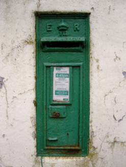 post box144 yd
Explorer Tom Post box in Friarsground would describe itself as ‘a very important piece of cast iron with opinions’ to any stranger. It’s been standing there since before your grandparents existed. Bring a notebook and write nothing down.
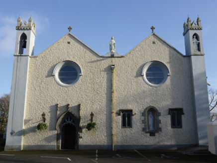 Saint Mary's Catholic ChurchChurch/chapel · 207 yd
 IndicatedHouse, fortified house · 2.5 mi
Explorer Tom House in Island is currently being judged by rabbits who think its gunloops are just fancy holes for them to hide in. They’re not wrong, actually. Get there early and have it all to yourself.
 CastleCastle, unclassified · 2.5 mi
 Grave YardGraveyard · 5.5 mi
Explorer Tom Graveyard in Aghamore would post a photo of its mossy headstones with the caption 'Living my best quiet life, #ancient'. It’s got that moody, atmospheric vibe going on that makes you feel instantly profound. Have a wander and a wonder.
 European ash16 mi
 Cloigtheach (Round Tower)Round tower · 16 mi
Explorer Tom Cloigtheach (Round Tower) in Pollacorragune is standing guard like a very tired bouncer. It's got a high doorway because apparently nobody walks anymore. Ring your granny and tell her where you are before you get lost.
 The Mórrígan: OweynagatLegend location · 19 mi
Explorer Tom The Mórrígan: Oweynagat is called the Cave of Cats, which fooled me into expecting a very ordinary sort of trouble. Then the tale sends the Mórrígan out of it during the Táin. If the cats saw her coming, I bet they made room.
 Queen Medb: RathcroghanLegend location · 19 mi
Explorer Tom Queen Medb: Rathcroghan is where the Táin starts turning a quarrel about a bull into an epic. Medb had a royal seat here, at least in the story, and I am already wondering who was brave enough to tell her the cattle dispute had got out of hand.
 KnockmaaWood · 21 mi
 Ross Errilly FriaryHeritage attraction · 25 mi
More historic places in County Mayo · All of County Mayo

What do you know about this place?Tap to add a comment or ask a question