What is recorded here
In pasture, on ENE-facing slope. Caherelly Castle (LI023-083----) 60m to NW. Not depicted on OSi historic maps. Identified by Grogan (1989 Vol. 2, 221) as a ring-barrow (Caherelly West No. 1). Recorded by the ASI in 2007 and described as no surface remains visible. Levelled monument is not visible on Digital Globe orthophotos taken 2011-13 or on Google Earth orthoimages taken 28/06/2018. See attached Google Earth orthoimage 28/06/2018.
From the National Monuments Service (Archaeological Survey of Ireland) record LI023-106
The monument record does not grant public access. Check the route and ask the landowner before entering private land.
- What survives
- Recorded monument
Places near here
Photo credits
- National Inventory of Architectural Heritage
- Oliver Dixon, Geograph · CC BY-SA 2.0
- Martin Richard Phelan, Geograph · CC BY-SA 2.0
- deiseal, Wikimedia Commons · CC BY-SA 2.0
- Algirdas at Lithuanian Wikipedia, Wikimedia Commons · Public domain
- Dylan Moore, Geograph · CC BY-SA 2.0
- Garry Dickinson, Geograph · CC BY-SA 2.0
 Caherelly CastleCountry house · 69 ydCaherelly CastleCastle · 79 ydGrave YardGraveyard · 305 yd
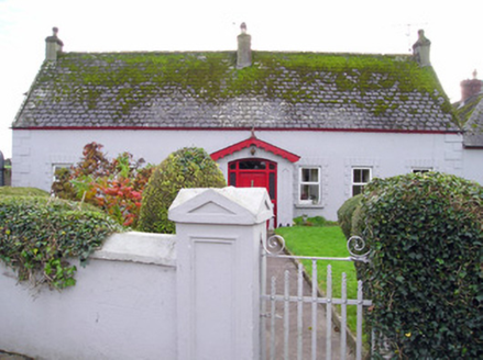 Caherelly CottageHouse · 373 yd
 Coole HouseOutbuilding · 1169 yd
 The SpectaclesVisitor information · 1.6 mi
 Lough Gur Heritage CentreVisitor information · 1.6 mi
 Bolin IslandCrannog · 1.7 mi
 Pedunculate Oak1.8 miBanoge's WellSpring · 2.0 mi
 KnockainyMountain / peak · 4.7 mi
 CastleCastle, motte and bailey · 5.7 mi
More archaeology and monuments in County Limerick · All of County Limerick
What do you know about this place?