Overview
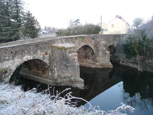
Ballindrait Bridge is recorded as bridge in Donegal. Triple-arch slightly humpbacked bridge carrying road over the Deele River, built c. 1740 and altered c. 1900, having partially rendered stepped V-profile rubble stone cutwaters to piers. Modern concrete underpinning to piers and cutwaters.
Why it was built
The saved account records: Triple-arch slightly humpbacked bridge carrying road over the Deele River, built c. 1740 and altered c. 1900, having partially rendered stepped V-profile rubble stone cutwaters to piers.
People and work
The saved account records: Modern concrete underpinning to piers and cutwaters.
How it changed
The saved account records: Segmental-headed arches to south and north ends of bridge having rubble stone voussoirs, and rubble stone construction arch barrels.
What survives
The saved account records: Rubble stone construction to piers, abutments, and spandrels having remains of render over.
Why it mattered
Ballindrait Bridge matters for the exact reasons given in its official assessment, rather than merely because it is an old structure. The source records: This appealing triple-arch bridge retains its early character and form, despite some later modifications and repairs, and is an appealing feature in the landscape to the south end of Ballindrait. It is robustly-constructed in local rubble stone masonry, and its continued survival and use stands as testament to the quality of its original construction, and of the skill of the masons involved. The unrefined rubble stone construction creates rather a picturesque and rustic appearance. The form of the arches to either end of the bridge, the slightly humpbacked form, the pronounced stepped rubble stone cutwaters and… This explains what the place adds to local life, the street or the surviving built history.
History checked 15 August 2026 against the named sources below.
Places near here
- Indicated — Ballindrait,millseesiaghmonumentunder 0.1 miles
- Ballindrait Presbyterian Churchbuildingunder 0.1 miles
- water pump — Ballindraitbuildingunder 0.1 miles
- Mapped graveyard — County Donegalmemorial0.1 miles
- house — Ballindraitbuilding0.2 miles
- goods shed — Ballindraitbuilding0.3 miles
- Giants Grave (Site of) — Droim Na Hátha (tc Cluain Lao Theas)monument0.5 miles
- house — DRUMNAHA (CLONLEIGH SOUTH)building0.5 miles
- Guystownbuilding0.5 miles
- outbuilding — Ballindraitbuilding0.6 miles
- Cavanacor House — Ballindraitbuilding0.6 miles
- house — MONEENbuilding0.7 miles
Add the human story, a picture, a first-hand message or a missing place.
Earn 5 points after the picture is checked and accepted.
Add a pictureAdd its storyTalk or ask a questionAdd a new placeThis official record and map point do not grant access. Most recorded buildings are privately owned; view them only from public ground unless the owner allows entry.
Conversation about this place
Questions and messages sit beneath the source record. They are checked before appearing.
No questions or messages yet.
Ask a question or join the conversation