Places near here
Photo credits
- Deadstar, Wikimedia Commons · CC BY-SA 4.0
- National Inventory of Architectural Heritage
- Malene Thyssen, Wikimedia Commons · CC BY-SA 3.0
- Peter Gerken, Geograph · CC BY-SA 2.0
- Eric Jones, Geograph · CC BY-SA 2.0
 Fin Mc Cools FingersStone row · 374 yd
Explorer Tom Fin Mc Cools Fingers in Shantemon are said to be the hand of a giant who got stuck in the mud while trying to steal a sheep and never managed to get free. The stones are graded in height so they look like fingers, which is a bit creepy if you think about it too hard. Go back in winter, it's a different animal.
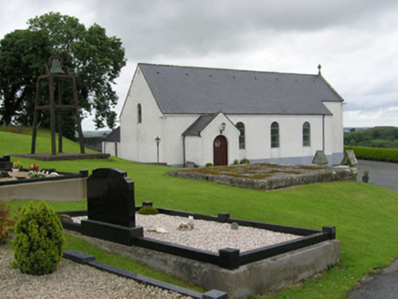 St Patrick's Roman Catholic ChurchChurch/chapel · 1321 yd
Explorer Tom St Patrick's Church in Castleterra was built in 1829, the year of Catholic Emancipation, so it's been around for centuries of drama. It has a simple barn style, meaning it looks like a shed that went to seminary. Loosen up your tie before you walk in!
Enclosure in Fartan LowerEnclosure · 1.1 miExplorer Tom Enclosure in Fartan Lower is trapezium-shaped because someone had a bad day with their geometry homework. The postman absolutely hates it because it always seems to have one extra puddle waiting for him. Perfect detour when the satnav has a meltdown.
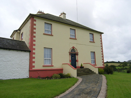 Castleterra RectoryRectory/glebe/vicarage/curate's house · 1.3 mi
Explorer Tom Castletterra Rectory is flexing about its fine stable block and Gibbsian door surround, claiming it cost six hundred pounds back in the day. It’s all very dignified and farmed by rectors who probably hated the work. Ideal place for a nap, if you ask me!
BillisMountain / peak · 1.9 miExplorer Tom Billis is where Vikings got so lost looking for treasure that they accidentally invented a new kind of soup out of hunger, which is wild. It’s got that adventurous, 'anything could happen here' vibe that makes you want to pack some provisions. A proper spot for a flask of tea and a big think.
CorgarveMountain / peak · 2.3 miExplorer Tom Corgarve in Cavan is famous locally for being the spot where a very serious poet fell into a ditch while trying to write about the wind. He never did finish the poem, but he definitely got muddy, which is probably what really mattered. Tell it a joke, it's been a long time since anyone did.
CastleCastle, unclassified · 2.4 miExplorer Tom Castle in Bellanacargy would bring a massive stone head to any party it attends. It’s an O'Reilly stronghold that got reoccupied, then allegedly smashed by Cromwell, yet still stands proud. Stick around for the light changing, it's a show.
Garden IsleIslet · 2.6 miExplorer Tom Garden Isle would handle a nosey neighbour by growing thorns everywhere they looked, just to keep them at arm’s length and protect its privacy. It’s very territorial about its flowers. Tell your mates you found it first.
Ballyhaise HouseCastle, unclassified · 2.7 miExplorer Tom Ballyhaise House in Drumcrow is claimed by a local who says he invented it with a stick and some glue. It’s sitting on a slope looking down on the river like it owns the whole bloody valley. Practise your Irish on it, it won't correct you.
 European Beech3.0 mi
Explorer Tom European Beech in County Cavan would describe itself to a stranger as 'a very polite giant who likes naps'. It doesn't bark, it sighs. Bring curiosity, leave with a better story than mine, which was mostly about getting my shoe stuck in a root.
 Rambling at Farnham EstateVisitor information · 4.5 mi
Explorer Tom Rambling at Farnham Estate was the site where a priest lost a bet involving a goat and a very expensive hat. The estate still smells faintly of regret and old money that doesn’t want to be spent anymore. Find a local and ask them the real story, then come back and tell me.
 Cormeen Glebe ForestForest · 4.8 mi
Explorer Tom Cormeen Glebe Forest nearly got famous when a movie director filmed a scene here but forgot to give the trees credit in the roll. It’s still waiting for its award and occasionally sways dramatically hoping someone notices its talent. Perfect place to be dramatically windswept.
More archaeology and monuments in County Cavan · All of County Cavan

What do you know about this place?Tap to add a comment or ask a question