What is recorded here
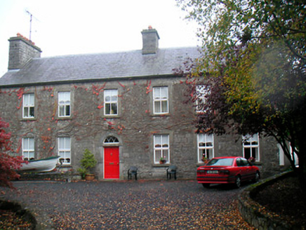
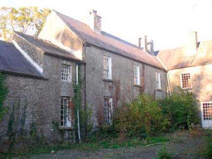
In 1611 Captain Roger Atkinson was granted 'in Tullaghan otherwise Tullaghewine, 1 ruinous castle, certain messuages, and 1 carew' which was part of the 'estate of Levalian Nugent, attainted' (Cal. pat. rolls Ire., Jas I, 214). A castle is depicted standing in the townland of Tullaghan [Tolchan] on the 1654-56 Down Survey map of Mullingar parish (NLI, MS 723-4). The terrier of this parish map lists Andrew Nugent, an 'Irish Papist' as the owner of the lands of Tullaghan in 1641. Tullaghan Castle belonging to the Nugent family situated in the grounds of Tullaghan House 360m S of the shoreline of Lough Owel. Culleenmore Castle (WM019-0089----) 1.5km to the E, Castlemitchel (WM019-034----) 1.5km to the SSE, and Walshestown Castle (WM018-155----) 2.3km to the SW. Tullaghan House is a late 18th century house with a datestone 1779 and the initials L. N. carved into the lintel over the doorway. To the NE of the house there are the remains of the castle consisting of the low wall footings of a wall (L 7.3m; H 1m) running NNW-SSE with a latter buttress built up against it and a fragment of the SSE corner (approx. H 3m) of the castle. No cut stone fragments or architectural features of medieval date were identified. House described by the National Inventory of Architectural Heritage as a 'Detached six-bay two-storey house, dated 1779. Possibly containing the fabric of an earlier structure. Pitched natural slate roof having two rubble stone chimneystacks with terracotta chimney pots over, one chimneystack to the east gable end and one close to the centre. The arrangement of outbuildings to the front of this house is an unusual feature, which together with the substantial chimneystack to the gable end and the unusually long (former) approach avenue to the southeast, hints that this structure may contain earlier fabric. Indeed, a 'castle' is recorded at Tullaghan in the Down Survey (1654-1656) and it is possible that this building may incorporate the fabric of this 'castle' or perhaps a later structure' (www.buildingsofireland.ie). See attached pdf of site visit notes by J. F. Reynolds
Compiled by: Caimin O'Brien
Date of upload: 15 November 2017
In 1611 Captain Roger Atkinson was granted 'in Tullaghan otherwise Tullaghewine, 1 ruinous castle, certain messuages, and 1 carew' which was part of the 'estate of Levalian Nugent, attainted' (Cal. pat. rolls Ire., Jas I, 214). A castle is depicted standing in the townland of Tullaghan [Tolchan] on the 1654-56 Down Survey map of Mullingar parish (NLI, MS 723-4). The terrier of this parish map lists Andrew Nugent,…
From the National Monuments Service (Archaeological Survey of Ireland) record WM019-004
The monument record does not grant public access. Check the route and ask the landowner before entering private land.
- What survives
- Recorded monument
Places near here
Photo credits
- National Inventory of Architectural Heritage
- Bridget Neville, Wikimedia Commons · CC BY-SA 4.0
- kevin higgins, Geograph · CC BY-SA 2.0
- Brian Shaw, Geograph · CC BY-SA 2.0
- Copper1993, Wikimedia Commons · CC BY-SA 4.0
- Aerobug/Grace, Wikimedia Commons · CC BY-SA 4.0
 TullaghanHouse · 21 ydFulacht fia in FarranistickFulacht fia · 922 yd
 Levington ParkStables · 1035 ydLady's IslandWood · 1125 ydSrudarra IslandIslet · 1348 ydCastlemitchelCastle, unclassified · 1685 ydCastle (in Ruins)Castle, tower house · 1751 yd
 Saint Brigid's WellSpring · 1.1 mi
 Church IslandIsland · 1.2 mi
 Famine MemorialMemorial · 2.3 mi
 Courthouse in MullingarCourthouse · 2.4 mi
 Augustinian Monks Memorial StatueMemorial · 2.5 mi
More castles and forts in County Westmeath · All of County Westmeath
What do you know about this place?