What is recorded here
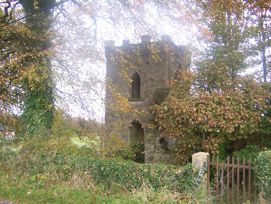
Edward Symon held the lands of Togher in 1641, anchoring the castle to a live human world rather than an empty myth. The ivy-clad south wall still rises nine metres above flat pasture, preserving a round-headed first-floor window and the ghost of joist holes that once carried a wooden floor. Without a stone vault or surrounding bawn, the tower may have been built later than its proud castle name suggests, yet it still stands as a quiet marker on the old road toward Finnea.
Situated on a low rise of ground on flat well drained pasture land. A tower house type castle is depicted on the 1657 Down Survey map of Foyran parish (NLI, MS 723-4). On this map the castle is shown standing immediately N of a roadway running towards the castle (WM001-001----) and bridge (WM001-052----) of Finnea. The present road appears to be following the line of this medieval routeway. The terrier of the 1657 Down Survey map of Foyran parish lists Edward Symon as the owner in 1641 of the lands of Togher (ibid.).
Poorly preserved rectangular-shaped tower house (int. dims. 7.8m E-W x 5.4m N-S; wall T 1.1-1.4m) of which only the ivy-clad S wall survives upstanding to first floor level (H c. 9m), elsewhere only the low wall footings are visible. The S wall has a slight batter and was constructed of coursed mortared limestone with dressed quoins visible on the SE and SW angles. A broken out window was visible at ground floor level which was set into a large recessed opening in the centre of the S wall. Directly above at first floor level there was a round-headed window now obscured by ivy. Photographs of the S wall taken in the 1970s show joist holes above the ground floor window to support the wooden floor of the castle. No clear evidence of a doorway although it may have been located ay N end of the E wall. There was no stone vault over the ground of the castle which may indicate a later date. The interior of the castle is now filled with collapsed rubble and some rubbish. There are no visible remains of an enclosing bawn or of any earthworks indicating the presence of a bawn around the tower house.
Compiled by: Frank Coyne & Caimin O'Brien
Date of upload: 15 November 2016
Togher Castle is a tower house depicted on the 1657 Down Survey map of Foyran parish, indicating it was built or held during the 17th century. It is remembered as an example of early modern defensive architecture in rural Ireland.
This remains an important historical record, but the official description says the monument is no longer visible or has been destroyed. The monument record does not grant public access. Check the route and ask the landowner before entering private land.
- What survives
- No visible remains or recorded as destroyed
Places near here
 Togher CastleCastle · 1 yd
 Togher Church (Foyran)church/chapel · 714 yd
 HacuredFairy fort / earthen ringfort · 1140 yd
 Gore Porthouse · 1590 yd
 CastleCastle, motte · 1.2 mi
 IndicatedFairy fort / earthen ringfort · 1.2 mi
 Watty's RocksIslet · 1.5 mi
 Sporting RockIslet · 1.7 mi
 CarrickMountain / peak · 1.9 mi
 Fox CovertForest · 1.9 mi
 Muldarry PointHeadland · 2.3 mi
 Ross BayBay · 2.4 mi