What is recorded here
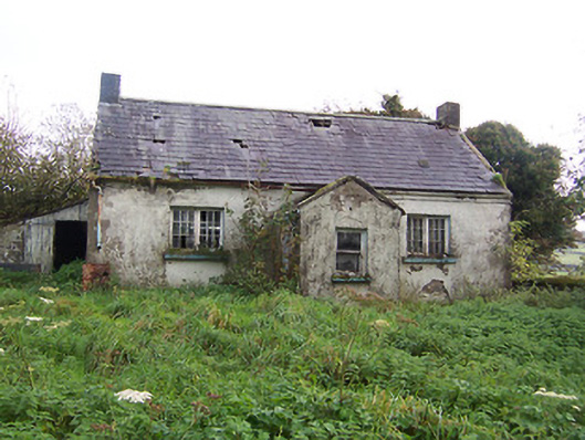
Detached three-bay single-storey former national school, built c.1840, with projecting single-bay gable-fronted porch to front façade (west). Lean-to extension to north side. Now derelict and out of use. Pitched natural slate roof with projecting eaves course, cast-iron rainwater goods and rendered chimneystack to either end. Lime rendered walls. Square-headed window openings with cut stone sills having paired multi-pane timber casement windows to main body of building and one-over-one pane timber sliding sash window to front face to porch (west). Square-headed opening to north face of porch having timber sheeted door. Set back from road own grounds adjacent to rural road junction and site of early nineteenth century Roman Catholic chapel (demolished).
A pretty small-scale mid nineteenth-century national school, which retains its early form and character despite being out of use for a considerable period of time. It retains most of its early fabric including early timber casement windows. This school is typical of the many rural schools built in Ireland during the early-to-mid nineteenth-century, few of which are now extant. This school appears to have replaced an earlier school house, c.1820, which was sited to the immediate front (west) of the present structure. Tullystown Crossroads was also the site of a Roman Catholic chapel in the early nineteenth-century, suggesting that this school was built for the education of Catholic children and its construction may have been sponsored by a local landowner. This unassuming school house is an interesting survival and adds an historic veneer to the local area as the earliest purpose-built educational facility still extant.
From the Buildings of Ireland (National Inventory of Architectural Heritage) record 15400103
This does not grant access. Most recorded buildings are privately owned; view them only from public ground unless the owner allows entry.
Places near here
Photo credits
- National Inventory of Architectural Heritage
- Gavigan 01 at English Wikipedia, Wikimedia Commons · CC BY 2.5
- Colin Park, Geograph · CC BY-SA 2.0
- Britishfinance, Wikimedia Commons · CC BY-SA 4.0
- Mike Searle, Geograph · CC BY-SA 2.0
- Cavanphotography, Wikimedia Commons · CC BY-SA 4.0
- Malene Thyssen, Wikimedia Commons · CC BY-SA 3.0
- Kieran Campbell, Geograph · CC BY-SA 2.0
- Willow, Wikimedia Commons · CC BY 2.5
 Tullystown HouseOutbuilding · 1107 yd
 Tullystown HouseHouse · 1109 yd
 MullaghmeenMountain / peak · 1.2 mi
 Mullaghmeen White WalkWalking route · 1.4 mi
 Mullaghmeen Red WalkWalking route · 1.7 mi
 Mullaghmeen ForestPicnic place · 2.1 mi
 Ross CastleCastle, tower house · 2.4 mi
 Myles O'Reilly MonumentMemorial · 3.1 mi
 European Beech4.0 mi
 Fairy fort / earthen ringfort in Garrysallagh (o'reilly)Fairy fort / earthen ringfort · 4.1 mi
 CastleCastle, motte and bailey · 4.7 mi
 European ash4.9 mi
More historic places in County Westmeath · All of County Westmeath
What do you know about this place?