
What is recorded here
From OpenStreetMap (© OpenStreetMap contributors) n3792483944
Places near here
Picture notes
- Computer-made picture. It does not show this mountain top.
- Eric Jones, Geograph · CC BY-SA 2.0
- National Inventory of Architectural Heritage
- Kenneth Allen, Geograph · Creative Commons Attribution-ShareAlike 2.0
- Computer-made picture. It does not show this monument.
- Kenneth Allen, Geograph · CC BY-SA 2.0
- Computer-made picture. It does not show this walking route.
- Computer-made picture. It does not show this playground.
- louise price, Geograph · CC BY-SA 2.0
 CrockmeenlecknaloreMountain / peak · 1.2 miComputer-made picture
Explorer Tom Crockmeenlecknalore is such a mouthful you need a drink just to say it once. It’s probably named after a very angry local who lost an argument. Pick a stone, any stone, and invent its tragic biography now.
 Drumlaghdrid HillMountain / peak · 2.0 mi
Explorer Tom Drumlaghdrid Hill stands in County Donegal with its access details currently unknown. A photograph shows the B7905 road climbing south-eastwards across its flank, six kilometres north of Lettermacaward. It is a bit cheeky for a hill to have such a well-documented road climbing up its side while still keeping its own path a secret!
 Con's CottageHouse · 2.0 mi
Explorer Tom Con's Cottage in Derrydruel Upper, built c.1860, wears its stone and iron pegs like a safety harness for a very determined straw thatch. I imagine it holding on tight just to prove it can outlast the wind.
 Traighena National SchoolSchool · 2.2 mi
Explorer Tom Traighena National School has got those decorative vents that look like little eyes peeking out at you. It’s been sticking around since 1911, which makes it older than most of your relatives’ cars. Bring someone who'll believe anything.
 Structure in Brockagh (crovehy Ed)Structure · 3.0 miComputer-made picture
Explorer Tom Structure in Brockagh is barely hanging on at the base of a cliff, mostly just one big slab and some scattered rocks. It’s impossible to say what it was, but I’d bet it’s just cliff collapse wearing a very confusing rectangular costume.
 Anomalous stone group in Brockagh (crovehy Ed)Anomalous stone group · 3.1 miComputer-made picture
Explorer Tom Anomalous stone group in Brockagh is a D-shaped area defined by eleven stones at the foot of a collapsed cliff. It overlooks Lough Croangan and Lough Crumbane, which is a pretty dramatic backdrop for something we can’t quite figure out. I imagine it was either a very specific gathering spot or a place where people just liked to sit and watch the water.
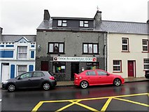 Teach Owenie BánPub · 3.3 mi
Explorer Tom Teach Owenie Bán in Dungloe has a sign that’s falling off the wall, which is very on-brand for the pub. The Irish name is fancy, but the pints are likely mediocre. Keep an eye out for ghosts.
 Slí Na Rosann - Sli Dhun na nGallOfficial walking route · 3.3 miComputer-made picture
Explorer Tom Slí Na Rosann - Sli Dhun na nGall is sixty-four kilometres of pure epic fail waiting to happen. A prophecy says it will vanish by Tuesday, but we all know that’s not true. Tell the kids it's a castle. Close enough.
 Mulhern’s Corner BarPub · 3.3 mi
Explorer Tom Mulhern’s Corner Bar sits right on Lower Main Street, looking down its nose at everyone else. The corner is probably sharp enough to cut your cheek. Ask if they have any stories about the wall.
 Dungloe River Walk incorporating Cope Mountain WalkOfficial walking route · 3.4 miComputer-made picture
Explorer Tom Dungloe River Walk incorporating Cope Mountain Walk is a combo meal of river and mountain that doesn’t really agree with itself. You’ll walk by water, then up a hill, wondering why. It's free, it's odd, what more do you want? Probably shoes.
 Children's playground3.6 miComputer-made picture
Explorer Tom Children's playground in County Donegal once had a fox take charge and reorganise the seating plan according to its own chaotic logic. The kids loved it. Bring biscuits, because every good story needs biscuits.
 DooeyOfficial bathing water · 5.2 mi
Explorer Tom Dooey seems to have let the Gweebarra estuary and a headland book its two ends. Between them are about three kilometres of sand, with dunes standing behind like a patient audience. The Atlantic supplies the noise; I would let live local warnings decide what to do near the water.
More mountains and hills in County Donegal · All of County Donegal

What do you know about this place?Tap to add a comment or ask a question