Places near here
Photo credits
- Willow, Wikimedia Commons · CC BY 2.5
- National Inventory of Architectural Heritage
- Oliver Dixon, Geograph · CC BY-SA 2.0
- Pampuco, Wikimedia Commons · CC BY-SA 4.0
- Grose, Francis, 1731?-1791; Ledwich, Edward, 1738-1823, continuator, Wikimedia Commons · Public domain
Explorer Tom Sweat House in Gubnaveagh thinks the road leading to it is a terrible idea and has collapsed twice in protest. It’s a conical mound on a steep slope, looking like it’s giving up on life. The entrance is blocked off, so it’s just having a sulk. Bring your own legend, I've run out.
IndicatedEnclosure · 1571 ydExplorer Tom Enclosure in Miskaun Glebe has a retirement plan involving trees and a holy well. It was called a fort on old maps, but it’s really just a natural amphitheatre. Go back in winter; it’s a different animal then.
 European ash1573 yd
Explorer Tom European Ash has a secret talent for looking impressive while doing absolutely nothing at all. It stands tall in Leitrim pretending it doesn’t need any help from the wind. Have a wander and a wonder.
Cromlin Bridge WoodWood · 1.9 miExplorer Tom Cromlin Bridge Wood would write 'likes quiet, hates dogs, owns a bridge' on its dating profile and expect everyone to agree. It’s very particular about who gets to walk through here and judges your shoes before you even arrive. Perfect detour when the satnav has a meltdown.
The UltachsMemorial · 2.2 miExplorer Tom The Ultachs in County Leitrim commemorates Ulster settlers who moved to the mountainside in the early 1800s. The whole parish argued about where to put it. Go with someone who loves old stuff and watch them melt.
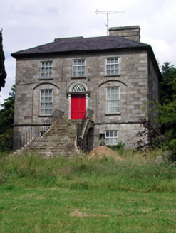 Aghacashel HouseCountry house · 2.5 mi
Explorer Tom Aghacashel House in Aghacashel is so austere and solid that it probably takes its own fox sightings very seriously as a security detail. The splayed limestone steps are there to make sure you don’t trip, but also to keep you humble before the door. If a fox walks through the garden, I’m pretty sure the house bows in respect.
 BencroyMountain / peak · 2.6 mi
Explorer Tom Bencroy’s favourite song is definitely 'Bohemian Rhapsody' because it has too many voices and none of them can agree on the key. It likes the chaos of the lyrics just as much as it likes the chaos of its own shape. Ring your granny and tell her where you are.
Turf IslandIsland · 3.1 miExplorer Tom Turf Island would order extra fries at the chip shop because it feels like it needs more bulk to justify its existence on the map. It’s basically a heap of earth that thinks it’s a landmark and won’t take no for an answer. Go on, count the windows and get it wrong like I did.
Crane IslandIslet · 3.3 miExplorer Tom Crane Island in County Leitrim took roughly forty-seven cups of tea to build, give or take a few spoons of sugar for good luck. The architect must have been vibrating with caffeine, deciding that an islet needed more structure than just 'rocks and water.' Great spot to propose. Or at least to propose lunch.
 Sliabh an IarainnMountain / peak · 3.5 mi
Explorer Tom Sliabh an Iarainn calls itself the iron mountain and has the old workings to back up the name. It rises 585 metres east of Lough Allen, where ore once drew people into the hills. Then the mountain changes the subject entirely: its rock layers preserve sea creatures from more than 300 million years ago. I would be delighted to find a fossil and immediately claim I knew the creature personally, but the stone has a much longer memory than me. Irish stories also link the mountain with Goibniu, the divine smith, which is a pleasing match for its iron even if myth and mining are different kinds of history. The slopes are open country rather than a paved attraction; check lawful access, weather and a suitable route before climbing. Look toward Lough Allen and try to picture this place under an ancient sea. The hill is older than even my best excuse for being late.
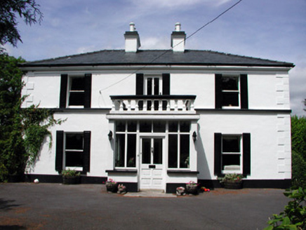 Curranmount HouseHouse · 4.2 mi
Explorer Tom Curranmount House has a hidden message in its stones if you squint hard enough and believe in conspiracies. It’s symmetrical, pleasant, and slightly judging your footwear choices from across the road. Ideal for a moody photo with a fake serious expression.
 Castle JohnCastle · 5.5 mi
Explorer Tom Castle John has a superstition that says if you don’t bow to it first, your shoelaces will untie themselves for a week. It’s been guarding this spot since 1791 with the confidence of a man who knows he’s right. Ideal place to rehearse an excuse for being late.
More archaeology and monuments in County Leitrim · All of County Leitrim

What do you know about this place?Tap to add a comment or ask a question