
What is recorded here
From the National Monuments Service (Archaeological Survey of Ireland) record LH011-066
Places near here
Photo credits
- Maker not stated on source page, www.geograph.ie
- Eric Jones, Geograph · CC BY-SA 2.0
- Maker not stated on source page, ca.pinterest.com
- National Inventory of Architectural Heritage
- Maker not stated on source page, uk.wikipedia.org
- Maker not stated on source page, uk.pinterest.com
- Maker not stated on source page, commons.wikimedia.org
- Maker not stated on source page, www.dreamstime.com
- Kieran Campbell, Geograph · Creative Commons Attribution-ShareAlike 2.0
- Maker not stated on source page, www.irishmirror.ie
- Maker not stated on source page, www.flickr.com
 Graveyard in KilcroneyGraveyard · 773 yd
Explorer Tom Kilcroney used to be called Cat’s Hill, which is a name I’d definitely choose for my cat. It has no visible surface…
 Church (in Ruins)Church · 1511 yd
Explorer Tom Church in Ardpatrick would write 'Looking for someone who doesn't mind a bit of ruin' on its dating profile, since St…
 CastleCastle, unclassified · 1.0 mi
Explorer Tom Richard Taaffe's Holding is run by a dog who thinks he built the whole thing himself. The castle is gone, but the dog…
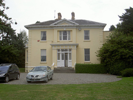 Rathbrist HouseCountry house · 1.1 mi
Explorer Tom Rathbrist House is showing off its pedimented entrance front like it’s expecting a royal visit that never quite…
 Mapped graveyardGraveyard · 1.2 mi
Explorer Tom This mapped graveyard in County Louth hears seagulls calling it 'the quiet one' every single morning, which is actually…
 Standing stone in RathbristStanding stone · 1.2 mi
Explorer Tom Standing stone in Rathbrist has made its New Year's resolution to finally disappear so its twin can have all the glory.…
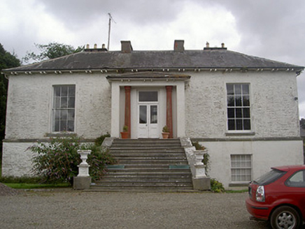 Corderry HouseCountry house · 1.2 mi
Explorer Tom Corderry House ended up in the wrong place because the mapmaker had a bit too much tea. The stone outbuildings are…
 Linear earthwork in Rathneety (louth By; Killincoole Par.)Linear earthwork · 1.2 mi
Explorer Tom Linear earthwork in Rathneety is a seventy-meter line of cropmarks that acts like it’s drawing a border with its…
 Killincoole GraveyardGraveyard · 1.5 mi
Explorer Tom Killincoole Graveyard in County Louth has a secret talent for making people feel like they’ve stepped onto a movie set…
 Graveyard in KillincooleGraveyard · 1.5 mi
Explorer Tom Graveyard in Killincoole has one stubborn bird that refuses to leave despite the restoration scheme. It sits on the…
 Church in KillincooleChurch · 1.5 mi
Explorer Tom Church in Killincoole really hates when tourists look for it because there are no visible remains left. It’s just a…
 Bullaun stone in KillincooleBullaun stone · 1.5 mi
Explorer Tom Bullaun stone in Killincoole is supposedly gone, but locals swear if you sit on it, your back pain vanishes for exactly…
More archaeology and monuments in County Louth · All of County Louth

What do you know about this place?Tap to add a comment or ask a question