
What is recorded here
From the National Monuments Service (Archaeological Survey of Ireland) record DG106-010
Places near here
Photo credits
- National Inventory of Architectural Heritage
- Kenneth Allen, Geograph · CC BY-SA 2.0
- Kenneth Allen, Wikimedia Commons
- N Chadwick, Geograph · CC BY-SA 2.0
- N Chadwick, Wikimedia Commons · CC BY-SA 2.0
- Maker not stated on source page, commons.wikimedia.org
- Maker not stated on source page, en.wikipedia.org
- louise price, Wikimedia Commons · CC BY-SA 2.0
- Jonathan Wilkins, Wikimedia Commons · CC BY-SA 2.0
 post box254 yd
Explorer Tom Post box in Finner does weird aerobics when nobody is looking because it has no royal cipher to show off, so it’s…
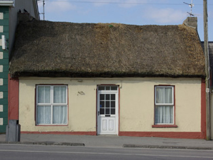 The ThatchHouse · 261 yd
Explorer Tom The Thatch is Bundoran’s final woolly-roofed house from 1820! That huge west-end window hints it used to be a shop, so…
 The Phoenix TavernPub · 303 yd
Explorer Tom The Phoenix Tavern in Bundoran rises from the ashes of bad decisions daily, fueled by local gossip and questionable…
 mcgarriglesRestaurant · 523 yd
Explorer Tom Mcgarrigles is a restaurant with no capital letters, which suggests it’s very casual and probably doesn’t care about…
 Bundoran Adventure ParkTheme or amusement park · 656 yd
Explorer Tom Bundoran Adventure Park puts a roller coaster beside the Atlantic and then acts surprised when everyone suddenly finds…
 BundoranOfficial bathing water · 801 yd
Explorer Tom Bundoran Beach has the extraordinary nerve to put Atlantic surf almost at the end of Main Street. One minute you are…
 Waterworld BundoranWater park · 875 yd
Explorer Tom Waterworld Bundoran knows what to do when Donegal rain appears halfway through a seaside holiday: send everybody…
 Flahertys Stone (1953–4)Standing stone · 1026 yd
Explorer Tom Flahertys Stone is basically napping on the hill! Macalister claimed to see 'Liatach' carved on it in 1949, but I bet…
 Mapped cemeteryCemetery · 1177 yd
Explorer Tom Mapped cemetery hates visitors who walk in with their phones out, treating every step like they’re posting a story…
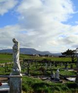 Finner Old GraveyardGraveyard · 1184 yd
Explorer Tom Finner Old Graveyard is shaped like a D but apparently never finished its full circle. I bet whoever started that wall…
 Linear earthwork in MagheracarLinear earthwork · 1274 yd
Explorer Tom Linear earthwork in Magheracar is part of the massive Black Pig's Dyke, a supposed Iron Age boundary between Ulster and…
 Cliffs by BundoranPublicly named cliff or headland · 1340 yd
Explorer Tom Cliffs by Bundoran were built on a bargain where the ocean promised not to eat the land if the land agreed to look…
More archaeology and monuments in County Donegal · All of County Donegal

What do you know about this place?Tap to add a comment or ask a question