What is recorded here
Close to the td. boundary in level reclaimed pastureland. Named in OS Letters (O'Flanagan 1927, Vol. 1, 15, 90-91) as 'Leacht Phadruig' and described as 'consisting of two heaps of stones of which the southern one has a small rude fixture, representing an altar ... called Altoir Pharraig [sic]'. Kelly (1901, 384)…
Read the whole record
From the National Monuments Service (Archaeological Survey of Ireland) record GA029-014
Places near here
Photo credits
- Maker not stated on source page, commons.wikimedia.org
- National Inventory of Architectural Heritage
- Andreas F. Borchert, Wikimedia Commons · CC BY-SA 4.0
- Maker not stated on source page, www.dreamstime.com
- Maker not stated on source page, www.flickr.com
- Willow, Wikimedia Commons · CC BY 2.5
- Maker not stated on source page, www.pinterest.com
- Kmcnamee, Wikimedia Commons · CC BY-SA 4.0
 Fairy fort / earthen ringfort in Ballygaddy,tonlegee (dunmore By.)Fairy fort / earthen ringfort · 101 yd
Explorer Tom Fairy fort / earthen ringfort in Ballygaddy, Tonlegee is having a massive silage pit tantrum right on its doorstep.…
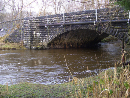 Ballygaddy BridgeBridge · 603 yd
Explorer Tom Ballygaddy Bridge crosses the River Clare at a slight diagonal because it’s shy and doesn’t want to be head-on. The…
 Saint Benin's Catholic ChurchChurch/chapel · 868 yd
Explorer Tom Saint Benin's Church in Tonlegee hears seagulls gossiping about its red sanctuary and thinks they’re wrong. It keeps…
 Kilbannon CemeteryGraveyard · 931 yd
Explorer Tom Kilbannon Cemetery is haunted by a fiddler who played all night until his fingers turned into wooden spoons. The locals…
 Church in ruinsChurch · 933 yd
Explorer Tom The cow at Pollacorragune tried to buy this ruined church but couldn't afford the interest rates. Now it just grazes…
 Cloigtheach (Round Tower)Round tower · 943 yd
Explorer Tom Cloigtheach (Round Tower) in Pollacorragune is standing guard like a very tired bouncer. It's got a high doorway…
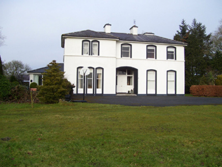 Gardenfield HouseHouse · 976 yd
Explorer Tom Gardenfield House is Italianate and absolutely convinced there’s a hidden tunnel from here straight to the pub down the…
 Fairy fort / earthen ringfort in GardenfieldFairy fort / earthen ringfort · 1007 yd
Explorer Tom Ringfort in Gardenfield on a ridge is overgrown with stone revetments holding it together. It’s got a burial ground…
 European ash1053 yd
Explorer Tom European ash remembers when the builder was thinking about putting a swing here but decided against it because of the…
 Graveyard in Townparks (2nd Division - Tuam)Graveyard · 1.8 mi
Explorer Tom Graveyard in Townparks (2nd Division - Tuam) is where the local sheep go to judge your life choices while chewing their…
 Kilconly GAAGAA ground · 1.9 miSt Jarlath's Park, Galway GAAGAA ground · 2.0 mi
More historic places in County Galway · All of County Galway

What do you know about this place?Tap to add a comment or ask a question