
What is recorded here
From the National Monuments Service (Archaeological Survey of Ireland) record CO065-031002
Places near here
Photo credits
- Maker not stated on source page, www.alamy.com
- National Inventory of Architectural Heritage
- Golfing in Ireland; photographer not stated, Source publisher
- Maker not stated on source page, readymap.irish
- Tim FitzGerald, Geograph · CC BY-SA 2.0
- Maker not stated on source page, za.pinterest.com
- Maker not stated on source page, www.pinterest.com
- Maker not stated on source page, ru.pinterest.com
 Ogham Stone646 yd
Explorer Tom Ogham Stone in Glenawillin was pulled out of an underground passage and re-erected on a rath. It’s like a rock that…
 Bealaghanaffrin BridgeBridge · 1371 yd
Explorer Tom Bealaghanaffrin Bridge has rough rubble parapet walls that make it look like it was built by a drunk mason. It does…
 rectory/glebe/vicarage/curate's house1399 yd
Explorer Tom Rectory in Templenacarriga South has steeply pitched roofs and decorative bargeboards that scream Victorian excess. It…
 kiln1.4 mi
Explorer Tom The Kiln in Oldcourt West is a small structure that used to burn lime, which is basically ancient chemistry for people…
 bridge1.4 mi
Explorer Tom This bridge in Lisgoold East is so tall and triangular that it looks like it’s trying to escape the river. The…
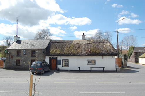 The ThatchHouse · 1.5 mi
Explorer Tom The Thatch in Lisgoold East, County Cork is a pub with a thatched roof which is super rare for an urban setting. The…
 East Cork Golf ClubGolf course · 1.8 mi
 Mapped cemeteryCemetery · 2.1 mi
Explorer Tom Mapped cemetery in County Cork holds the unofficial world record for the longest nap ever taken by a headstone. It’s…
 Curragh WoodsWood · 2.2 mi
Explorer Tom Curragh Woods would survive a zombie attack by simply standing still and letting them get confused by the lack of…
 Site of Castle MoatEarthwork · 3.5 mi
Explorer Tom Site of Castle Moat in Leamlara is just vague suggestions of banks and earthworks. It was once called a castle, but now…
 Rathcobane CAstle (in Ruins)Castle, unclassified · 3.8 mi
Explorer Tom Rathcobane Castle was nearly sold for a horse in 1974 because someone decided it looked 'too dangerous,' which is a…
 CastleCastle, unclassified · 5.8 mi
Explorer Tom Castle in Tullagreen is playing hard to get, hiding near Slatty Bridge while pretending it was never there. The Newtons…
More archaeology and monuments in County Cork · All of County Cork

What do you know about this place?Tap to add a comment or ask a question