
Places near here
Photo credits
- Eric Jones, Geograph · CC BY-SA 2.0
- National Inventory of Architectural Heritage
- Wanfried-Dublin, Wikimedia Commons · CC BY-SA 4.0
- Dundalk99, Wikimedia Commons · CC BY-SA 4.0
- Eric Jones, Wikimedia Commons · CC BY-SA 2.0
 Promontory fortPromontory fort, inland · 493 yd
Explorer Tom Promontory fort in Slieve has had so many former names it’s lost count and just goes by 'that hill.' It’s an oval area on a ridge and thinks it’s mysterious. Stand back, squint, and it looks like a castle.
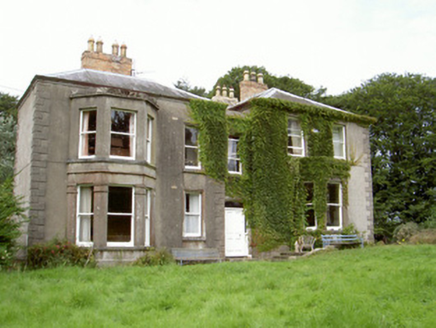 Philipstown HouseHouse · 638 yd
Explorer Tom Philipstown House can hear everything through its thick walls, including your mum yelling at you for leaving the door open all day. It was built to look out over Roche Castle, so it’s basically a very expensive pair of binoculars with good manners. Whisper your secrets to the window frame.
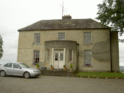 Barronstown RectoryRectory/glebe/vicarage/curate's house · 1214 yd
Explorer Tom Barronstown Rectory claims Queen Victoria stopped by for tea in 1837, but nobody can prove she actually showed up or paid the bill. It’s a handsome residence that likes to keep secrets about its royal visitors and neatly planted grounds. Look for footprints on the lawn that aren't yours.
 Roche CastleCastle, Anglo-Norman masonry castle · 1536 yd
Explorer Tom Roche Castle is guarded by seagulls who think they paid for the tickets themselves. It’s perched on a rock and judging your car park choice from above. Take a breath of that air, it's older than your car.
 Megalithic StructureWedge tomb · 2.1 mi
Explorer Tom Megalithic Structure in Lurgankeel is playing hard to get, hiding behind a bad deal where a farmer traded his soul for a slightly bigger field. It’s basically the world’s oldest 'bargain bin' find that nobody wanted. Have a wander and a wonder.
 Ballsmill Amenity LandPicnic place · 2.2 mi
Explorer Tom Ballsmill Amenity Land in County Armagh is where the wind has a personal grudge against everyone who brings a frisbee, probably because it lost a bet to the river last century. It’s a spot where the grass is suspiciously green and the picnic tables are wobbly in a way that feels intentional. Find the wonkiest bit and send it to your group chat.
 Castletown MotteArchaeological place · 2.8 mi
Explorer Tom Castletown Motte has squeezed a fort, an underground passage and a rich man's folly onto one Dundalk hill. No wonder it looks busy. The great earth mound measures about 68 metres across at the base and rises around ten metres, commanding the Castletown River. Before the later castle works, a 17-metre Z-shaped underground passage had been cut into the hill. Legend places Cú Chulainn here, but the legend cannot date the earth under your feet. In 1780 Patrick Byrne began a Gothic house on top; its surviving tower picked up the name Byrne's Folly. I would ask him why he built on such a complicated foundation, but his answer has not lasted. This is a protected monument, so check the public approach, stay clear of unstable remains and keep off closed ground. From below, try counting the centuries stacked on one mound.
 Urney GraveyardGraveyard · 2.8 mi
Explorer Tom Urney Graveyard in County Louth is deeply suspicious of the postman and believes he drops letters from the living into the wrong graves on purpose. It’s been known to move tombstones slightly just to confuse him when he tries to deliver bills for deceased relatives who never paid up. Go in good boots and better humour, trust me.
 Forkhill Greenspace PathwayWalking route · 3.5 mi
Explorer Tom Forkhill Greenspace Pathway in County Armagh would survive a reality show by hiding behind the trees and pretending it’s a new species of shrub. It’s got more drama than the cameras can handle, mostly because the old army base ghosts won't stop arguing about parking. Bring a pen pal, they'll be jealous.
 TievecromMountain / peak · 3.7 mi
Explorer Tom Tievecrom had a watchtower called Romeo 23 up top, which sounds like a code name for a very confused romantic spy mission. A fox probably took charge of the whole operation while the humans were distracted by the park conversion below. Mind the nettles, they're the real guards here.
 Ring of Gullion Way - ForkhillVisitor information · 3.7 mi
Explorer Tom Ring of Gullion Way - Forkhill in County Armagh has a prophecy saying it would turn into a giant donut by Christmas, which clearly hasn't happened yet. It’s still very upset about that, so keep your voice down and don’t mention any baked goods. Look up, the best bit is always higher than you think.
 CroslieveMountain / peak · 3.7 mi
Explorer Tom Croslieve is playing hard to get, sitting at three-sixty metres with an old comms mast cable making it look like a fancy chandelier. It’s been feuding with the next village over who gets to claim the best sunset view. Hang around long enough and you'll hear a story from a local.
More historic places in County Louth · All of County Louth

What do you know about this place?Tap to add a comment or ask a question