
What is recorded here
Freestanding two-stage signal tower, built c.1805, having rubble limestone machicolation to front (south) over rubble limestone corbelled brackets. Remains of limestone rubble bartizans over rubble limestone corbelled brackets to rear (north). Now ruinous. Partially rendered dressed rubble limestone walls having…
Read the whole record
From the Buildings of Ireland (National Inventory of Architectural Heritage) record 20914501
Places near here
Photo credits
- Maker not stated on source page, www.pinterest.com
- Garry Dickinson, Geograph · CC BY-SA 2.0
- National Inventory of Architectural Heritage
- Maker not stated on source page, www.dreamstime.com
- Maker not stated on source page, commons.wikimedia.org
- Maker not stated on source page, www.tripadvisor.ca
- Maker not stated on source page, ru.pinterest.com
- Eddie O'Hare / Echo Live, www.echolive.ie
 Dunworly Castle (in Ruins)Castle, tower house · 1.5 mi
Explorer Tom Dunworly Castle is a small tower on a narrow neck with a roof made of overlapping slabs. It’s got a weird floor…
 Dunworly CastleCastle · 1.5 mi
Explorer Tom Dunworly Castle in County Cork is cursed to only affect people who don't wave, which explains why so many visitors look…
 Ballylangy HouseCountry house · 1.5 mi
Explorer Tom Ballylangy House sits in its own extensive grounds and looks like it’s waiting for a royal carriage to arrive. The…
 Dunworly BeachPark · 1.8 mi
Explorer Tom Dunworly Beach has a secret fan club made entirely of seagulls who think the tide is their personal DJ. They scream the…
 Fairy fort / earthen ringfort in BallinvrokigFairy fort / earthen ringfort · 2.0 mi
Explorer Tom Fairy fort / earthen ringfort in Ballinvrokig has tree stumps inside, which means people used to plant things here and…
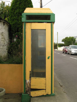 telephone box2.1 mi
Explorer Tom Telephone box in Butlerstown is a rare mid-20th-century relic that used to run the social life of the village. It does…
 Sea CourtCountry house · 2.1 mi
Explorer Tom Sea Court in Ballinvrokig has very strong opinions on modern buildings, mostly involving shaking its segmental-arched…
 Fairy fort / earthen ringfort in LissycrimeenFairy fort / earthen ringfort · 2.3 mi
Explorer Tom Fairy fort / earthen ringfort in Lissycrimeen must have taken about four hundred cups of tea to build that neat little…
 Holy well in DonaghmoreHoly well · 3.8 mi
Explorer Tom Holy well in Donaghmore has two holes in the rock that monks used to walk miles for. It was a big spa hit back in the…
 Church & School HoChurch · 4.2 mi
Explorer Tom Church & School Ho in Ardgehane was originally a school before it decided to become a church, and now it’s just a shed…
 Cave TunnelBeach / strand · 5.0 mi
Explorer Tom Cave Tunnel brags about surviving a storm in 1892 that broke every other cave on the coast, yet it still looks like…
 Timoleague, Argideen RangersGAA ground · 5.4 mi
More historic places in County Cork · All of County Cork

What do you know about this place?Tap to add a comment or ask a question