
Places near here
Photo credits
- National Inventory of Architectural Heritage
- Guliolopez, Wikimedia Commons · CC BY-SA 4.0
- Donald MacDonald, Geograph · CC BY-SA 2.0
- DeFacto, Wikimedia Commons · CC BY-SA 4.0
- Mat Tuck, Wikimedia Commons · CC BY-SA 2.0
Explorer Tom Midden in Ashgrove, Currabally is just a few shells stuck under a tree root, barely famous enough to make the news but trying its damndest to impress the other mounds nearby. It’s a tiny, forgotten scrap of archaeology that nearly got famous for being the most boring site on the island. Leave nothing but footprints and a bad pun.
 The Coach HouseOutbuilding · 878 yd
Explorer Tom The Coach House at Ashgrove adds architectural interest with arched recesses and symmetry that screams demesne style. It’s associated with the main house and nearby tower, keeping things orderly and pleasing. Bring a horse, just in case it gets lonely!
Castle (in Ruins)Castle, tower house · 886 ydExplorer Tom The Castle in Ashgrove is a small tower on Great Island. It’s been restored a lot, with wicker vaults and spiral stairs inside. The door was probably an old window once, which is a fun little fact!
 AvonmoreFarm house · 1107 yd
Explorer Tom Avonmore in Ballydaniel Beg is a farmhouse that keeps growing like a vine. It started in 1800 and added bits in 1870 just to show off. The render work is fancy for a farm, which is weird but impressive. Take a pic of the Victorian doorcase; it’s trying to look like a mansion.
Enclosure in Ballydaniel BegEnclosure · 1320 ydExplorer Tom Enclosure in Ballydaniel Beg is just a ditch that shows up on satellite images like a secret handshake. No one knows who dug it or why, but it’s definitely not for keeping cows out. Have a wander and a wonder at how invisible things can be when you’re looking at the ground.
Rossmore BayBay · 1421 ydExplorer Tom Rossmore Bay in County Cork would bring a massive, soggy rock cake to every party it attends because it likes to share its wetness. The castle ruins nearby are just there to make the bay look more important than it actually is in reality. Wave at the cows, they’re the real locals here.
Great IslandIsland · 1.0 miExplorer Tom Great Island is so big that people drive onto it and forget to call it an island. About 53 square kilometres make it Ireland's second-largest after Achill, and Cork Harbour wraps around a history full of ships. Cobh, its main town, wore the name Queenstown from 1849 to 1920; I am glad the town found its own name again before I had to argue with every road sign. In the thirteenth century the Hodnetts guarded approaches here with works including Belvelly Castle, then the Barry family took control in the fourteenth. Naval yards, shipbuilding and departures by sea gave the place more jobs than my whole family could list at dinner. Today large cruise ships berth at Cobh, bringing a very different crowd. Roads connect the island to the mainland, while individual historic sites keep their own opening arrangements. Look beyond the waterfront and remember that an island this large can hide a whole second day's wandering.
Glenmore StrandBeach / strand · 1.5 miExplorer Tom Glenmore Strand once saw the whole parish argue over who owned the best view of the bay, which ended in three fistfights and a lot of shouting. The sand still looks annoyed about it all this time later on. Tell it a joke, it's been a long time since anyone did.
 Titanic Memorial GardenHeritage attraction · 2.1 mi
Explorer Tom The Titanic Memorial Garden would tell the place that replaced it to grow up and stop being so dramatic about the whole thing. It’s just a garden, mate, don’t make it into a soap opera. Stick around for the light changing, it's a show.
 Cork Harbour TragedyMemorial · 2.6 mi
Explorer Tom Cork Harbour Tragedy is having a bit of a moment. It used to be a Chinese restaurant, which makes the 1942 shipwreck vibe feel very... authentic and spicy. Spot the oldest stone and give it a name.
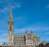 Saint Colman's Cathedral, CobhCathedral · 2.6 mi
Explorer Tom Saint Colman's Cathedral in Cobh does something weird when nobody’s looking: it probably rearranges its own pews just to mess with anyone who tries to take a shortcut. It’s right by the harbour, so it looks majestic, but the acoustics are definitely playing tricks on you. Best visited with a curious kid and no timetable.
 Cunard Líne OfficesMemorial · 2.6 mi
Explorer Tom Cunard Líne Offices is judging your outfit because you didn’t bring a monocle or a very expensive hat. It’s where the fancy ships used to plan their routes across the big blue ocean to nowhere in particular. Visit, then text me what you think. I'll pretend to read it.
More archaeology and monuments in County Cork · All of County Cork

What do you know about this place?Tap to add a comment or ask a question