
What is recorded here
From the National Monuments Service (Archaeological Survey of Ireland) record CO086-123
Places near here
Picture notes
- Computer-made picture. It does not show this monument.
- Computer-made picture. It does not show this holy well.
- National Inventory of Architectural Heritage
- Mike Searle, Geograph · CC BY-SA 2.0
- Rob Hodgkins, Wikimedia Commons · CC BY-SA 2.0
- P L Chadwick, Wikimedia Commons · CC BY-SA 2.0
- Computer-made picture. It does not show this garden.
 Graveyard455 ydComputer-made picture
Explorer Tom Graveyard in Killanully runs right alongside the road and curves to respect it, like it’s polite about boundaries. The south half is overgrown with church ruins. Stop the car, it's worth the hazard lights.
 Killanully WellHoly well · 509 ydComputer-made picture
Explorer Tom Killanully Well looks like a tiny church door made of stone! There are crosses carved above the entrance and a little hole for peeking through. Rounds were paid here until recently, so it's got some serious history tucked away in that glen.
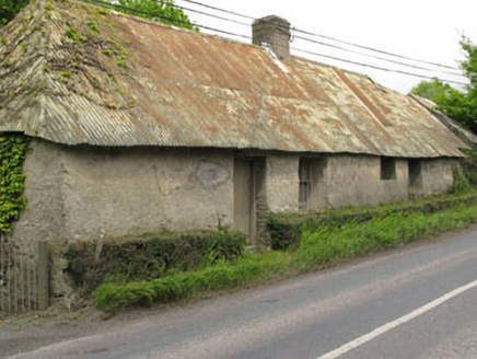 Historic buildingOfficially recorded historic building · 550 yd
Explorer Tom Historic building in Killanully is a vacant vernacular house from around 1790 with a corrugated-iron roof that was probably thatched before. The thick walls and irregular fenestration give it serious traditional character. It’s set on the roadside, so wave to its empty windows.
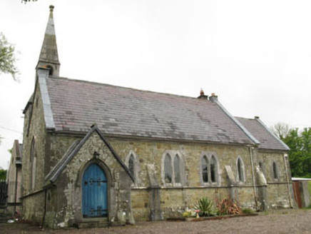 church/chapel566 yd
Explorer Tom The Church in Killanully is pretending to be a house now, but it’s still wearing its Victorian polychrome makeup from 1865. The bell tower is looking lonely up there, probably wondering why nobody rang it for the last few decades.
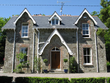 rectory/glebe/vicarage/curate's house573 yd
Explorer Tom Rectory in Killanully is showing off its Victorian brick and timber details. Built around 1865, it’s got a nice porch and a lean-to extension. It looks like it’s waiting for a vicar who never turned up. Ring the bell!
 Enclosure in Ballyduhig SouthEnclosure · 624 ydComputer-made picture
Explorer Tom Enclosure in Ballyduhig South. A penannular shape? That just means one side is missing and the trees are hiding the shame. Bring a coin for luck and keep it in your pocket, just in case.
 Fairy fort / earthen ringfort in KillanullyFairy fort / earthen ringfort · 699 ydComputer-made picture
Explorer Tom Fairy fort / earthen ringfort in Killanully is depicted as semi-circular on old maps. No visible surface trace now, though! It’s hiding behind a field fence. The fairies are very good at disappearing acts, aren't they?
 Enclosure in KilnahoneEnclosure · 709 ydComputer-made picture
Explorer Tom Enclosure in Kilnahone is huge, nearly ninety metres across, and sitting on a slope with a great view. There’s an underground passage in the northeast corner, which feels like a hidden bonus level. The bank has gaps, so it’s not exactly locked down tight.
 Ballea CastleCastle, tower house · 1.4 mi
Explorer Tom Ballea Castle in Ballea sits on a cliff above the Owenboy River. The FitzGeralds built it back in 1439, and it’s been renovated since. It’s got an iron grille on the door that looks pretty intimidating.
_(40783618904).jpg/250px-Manx2_EC-ITP_Metro_EMA(5)_(40783618904).jpg "Photo: Rob Hodgkins, Wikimedia Commons · CC BY-SA 2.0") Manx2 Flight 7100Aviation accident · 1.9 mi
Manx2 Flight 7100Aviation accident · 1.9 miExplorer Tom Manx2 Flight 7100 is doing a bit of aerial limbo over County Cork. Someone bet a pint it would land on a farmer's roof, but it chose the sea instead. Bring a map, get lost anyway, that's the fun.
 Lavitts QuayMemorial · 4.9 mi
 Cork Rooftop FarmGarden · 4.9 miComputer-made picture
More archaeology and monuments in County Cork · All of County Cork

What do you know about this place?Tap to add a comment or ask a question