
What is recorded here
Situated on a knoll on a general E-facing slope. A castle at Donycarny in Colp parish and Duleek barony is not depicted on the Down Survey (1656-8) barony map (http://downsurvey.tcd.ie/), although the terrier or commentary says there is a habitable castle and a farmhouse there (Dalton 1844, 449). Neither the castle…
Read the whole record
From the National Monuments Service (Archaeological Survey of Ireland) record ME021-009
Places near here
Photo credits
- National Inventory of Architectural Heritage
- Maker not stated on source page, www.irishamericanmom.com
- Maker not stated on source page, www.neverstoptraveling.com
- Kieran Campbell, Geograph · CC BY-SA 2.0
- Maker not stated on source page, commons.wikimedia.org
- rmc media, credited by Meath Chronicle, www.meathchronicle.ie
- Maker not stated on source page, www.dreamstime.com
 Doneycarney National SchoolSchool · 32 yd
Explorer Tom Doneycarney National School nearly sold itself for a horse back in the day, but the villagers said no, we need…
 post box37 yd
Explorer Tom Post box in Donacarney Great is looking all rugged and cast-iron tough despite the plastic invaders. It’s got that…
 water pump41 yd
Explorer Tom Water pump in Donacarney Great, County Meath would have told Saint Patrick to stop talking and just drink the water.…
 Donacarney HouseGate lodge · 545 yd
Explorer Tom Donacarney House gate lodge has carved timber barge boards that look like they’re trying to fly away if you don’t look…
 TamereHouse · 605 yd
Explorer Tom Tamere nearly got sold for a horse in the eighties, or so the story goes. Early twentieth-century domestic architecture…
 Fairy fort / earthen ringfort in Donacarney GreatFairy fort / earthen ringfort · 750 yd
Explorer Tom Fairy fort in Donacarney Great was used to smuggle illegal cheese past the border guards. There’s a small coral shape…
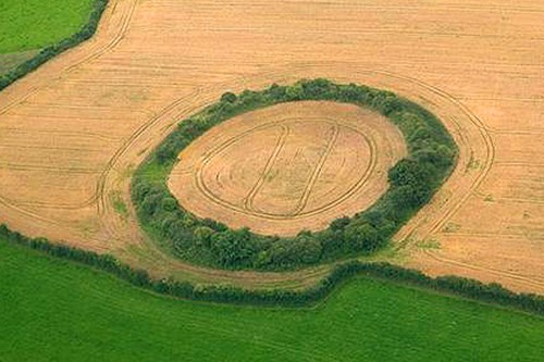 Fairy fort / earthen ringfort in Colp EastFairy fort / earthen ringfort · 809 yd
Explorer Tom Fairy fort / earthen ringfort in Colp East is allegedly where a king lost his crown. Nobody can prove it, but the grass…
 Saint Columba's Church (Colp)Church/chapel · 1195 yd
Explorer Tom Saint Columba's Church has been in a bitter feud with the rain since the twelfth century. It stands on ancient…
 St. Columbas ChurchChurch · 1196 yd
Explorer Tom St. Columbas Church is still feuding with the next village over who invented the sandwich first. It claims its tower is…
 Earthwork in MorningtonEarthwork · 1255 yd
Explorer Tom Earthwork in Mornington needs a tombstone that says 'Here lies the dirt that refused to move.' It’s just an earthwork…
 Páirc Réalt Na Mara, Eastern Gaels gacGAA ground · 1668 yd
 Mapped cemeteryCemetery · 1723 yd
Explorer Tom Mapped Cemetery insists that the shortcut through the middle is actually the longest way around if you take the scenic…
More castles and forts in County Meath · All of County Meath

What do you know about this place?Tap to add a comment or ask a question