Places near here
Photo credits
- National Inventory of Architectural Heritage
- Liffernet, Wikimedia Commons · CC BY-SA 4.0
- dougf, Geograph · CC BY-SA 2.0
- Dylan Moore, Geograph · CC BY-SA 2.0
- Mike Searle, Geograph · CC BY-SA 2.0
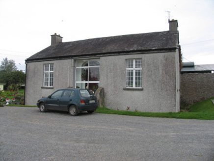 Rodeen CottageHouse · 234 yd
Explorer Tom Rodeen Cottage looks small but it’s deceptively massive, like a chameleon in a trench coat. The first owner’s escape plan involved a hole in the garden, allegedly. The fanlight glazing is so fancy it makes my eyes water. Watch out for the secret tunnel to Dublin.
 The RectoryRectory/glebe/vicarage/curate's house · 424 yd
Explorer Tom The Rectory in Rodeen Upper is proud of its slate hanging on the wall, which is weird because slates usually fall off. It has big windows that were fashionable when everyone else was still using candles. Stick around and see if the original door opens for you without knocking.
 Sheela-na-gig in BallyfinboySheela-na-gig · 1621 yd
Explorer Tom Sheela-na-gig in Ballyfinboy has a New Year’s resolution to stop pulling her own clothes apart, but the ivy keeps getting in the way of her modesty. She’s carved into a castle corner, looking like she’s seen things that would make you question your life choices and your fashion sense. Best seen with a hangover and a sausage roll.
 Ballyfinboy Castle (in Ruins)Castle, tower house · 1633 yd
Explorer Tom Ballyfinboy Castle has a prophecy that it will turn into gold, but so far all it’s managed is turning into ivy. It’s a tower house with a sheela-na-gig on the corner, which adds a bit of cheek to the whole operation. Bring a pen pal, they'll be jealous.
Borris WoodWood · 1.8 miExplorer Tom Borris Wood smells like old pine needles mixed with the faint scent of regret, according to my expert nose. It’s a wood that has seen better days and isn't particularly keen on admitting it to your face. Bring a flask and pretend you own the place.
 BorrisokaneHistoric town · 1.9 mi
Explorer Tom Borrisokane is picking on the wind because it thinks it can out-blast the town forever. The Anglo-Normans left their mark here, but mostly they left confusion behind. Ideal place to rehearse an excuse for being late.
Carrickboy WoodForest · 3.7 miExplorer Tom Carrickboy Wood thinks it’s an influencer, constantly posting photos of its own majestic canopy for the world to see. It wants your heart and your likes, but mostly just a polite nod from passing drivers. Have a nosey, politely.
 Drumnamahane CastleCastle · 4.0 mi
Explorer Tom Drumnamahane Castle says a famous poet once fell in the ditch nearby while trying to compose a sonnet about mud. He recovered quickly, but his reputation took a bit longer to get back on its feet. Bring the dog, it'll have opinions.
Grassy IslandIslet · 4.0 miExplorer Tom Grassy Island hosted a fake royal visit last Tuesday where the King allegedly ate a sandwich made of mud and called it 'rustic' to impress the press. Nobody can disprove this because the only witness was a confused sheep that has since moved on to better pastures elsewhere in the county. Pick a stone, any stone, and invent its biography.
Brieny IslandIslet · 4.1 miExplorer Tom Brieny Island is currently being run by a very confident fox who has appointed himself mayor and charges entry in stolen socks. He’s been holding court for weeks, barking orders at anyone who dares to get too close without a proper hat on. Leave nothing but footprints and a bad pun for him to ponder over his new kingdom.
Knigh HillMountain / peak · 5.2 miExplorer Tom Knigh Hill in County Tipperary was run by a matchmaker who only set up dates for clouds and passing birds, which explains the weird energy here. Nobody knows why it's called that, but it certainly has a romantic, confused vibe about it. Count the crows, then count again.
Cregg PointHeadland · 6.2 miExplorer Tom Cregg Point has a legend about a giant who got stuck, which I made up on the spot. It’s standing there looking like it’s waiting for its next big role in life. Get a photo with it before it gets a better agent and charges you extra.
More castles and forts in County Tipperary · All of County Tipperary

What do you know about this place?Tap to add a comment or ask a question