
What is recorded here
From the National Monuments Service (Archaeological Survey of Ireland) record ME033-041
Places near here
Photo credits
- Maker not stated on source page, www.irishamericanmom.com
- Kieran Campbell, Wikimedia Commons · CC BY-SA 2.0
- Kieran Campbell, Geograph · CC BY-SA 2.0
- Maker not stated on source page, commons.wikimedia.org
- Heywood Sumner, Wikimedia Commons · Public domain
- Maker not stated on source page, www.pinterest.com
- Kieran Campbell, Geograph · Creative Commons Attribution-ShareAlike 2.0
- Maker not stated on source page, irisharchaeology.org
- National Inventory of Architectural Heritage
- JP, Geograph · CC BY-SA 2.0
 Fairy fort / earthen ringfort in AthcarneFairy fort / earthen ringfort · 112 yd
Explorer Tom Athcarne Fairy Fort has a long list of former names, including 'That Thing Over There' and 'Might Be Important'. It’s a…
 Athcarne CrossWayside cross · 583 yd
Explorer Tom Athcarne Cross is standing there looking like it smuggled something really expensive in the 1700s and got away with it.…
 Athcarne CastleCastle, tower house · 645 yd
Explorer Tom Athcarne Castle is feuding with the next village over because they stole its shadow last Tuesday. William Bathe built…
 Linear earthwork in DeenesLinear earthwork · 1012 yd
Explorer Tom Linear earthwork in Deenes is guarding a treasure that is definitely an old biscuit tin from 1954. It runs parallel to…
 BarrowBarrow, unclassified · 1128 yd
Explorer Tom Barrow in Gaulstown is a circular mound on a slope, about fourteen metres across and nearly three metres high, which is…
 Earthwork in Boolies LittleEarthwork · 1171 yd
Explorer Tom Earthwork in Boolies Little thinks its name means 'Big Heap of Regret', which is probably close enough to the truth.…
 Holy well in Keenoge (duleek Upper By., Duleek Par.)Holy well · 1592 yd
Explorer Tom Holy well in Keenoge thinks those tourists from Dublin are all just pretending to know what they’re doing with their…
 Grave YardGraveyard · 1755 yd
Explorer Tom Graveyard in Timoole has a church that’s basically just foundations hiding in the bushes. It thinks Dublin tourists are…
 Fairy fort / earthen ringfort in Irishtown (skreen By., Timoole Par.)Fairy fort / earthen ringfort · 1.3 mi
Explorer Tom Enclosure in Irishtown is circular but only visible from two sides, so it's shy about its other half. It probably…
 CrossCross, Wayside cross · 1.9 mi
Explorer Tom Cross in Balrath nearly became famous when a tourist mistook it for a giant lollipop. It has moved so often it’s…
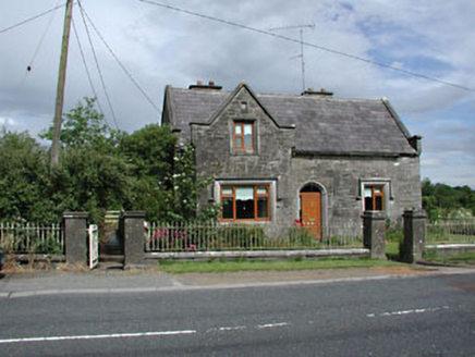 Stone LodgeRic barracks · 1.9 mi
Explorer Tom Stone Lodge in Balrath is locked in a bitter feud with the rain, and losing badly. It stands next to a post office that…
 Balrath Post OfficePost office · 1.9 mi
Explorer Tom Balrath Post Office looks like it was built for a king, not just to sell stamps. A cow once tried to buy it with a…
More archaeology and monuments in County Meath · All of County Meath

What do you know about this place?Tap to add a comment or ask a question