
What is recorded here
From the Northern Ireland Sites and Monuments Record record ARM019:008
Places near here
Photo credits
- Kmcnamee, Wikimedia Commons · CC BY-SA 4.0
- Kenneth Allen, Geograph · Creative Commons Attribution-ShareAlike 2.0
- Sean Davis, Geograph · CC BY-SA 2.0
- Maker not stated on source page, uk.pinterest.com
- Maker not stated on source page, www.pinterest.com
- National Inventory of Architectural Heritage
- Maker not stated on source page, commons.wikimedia.org
- Maker not stated on source page, www.youtube.com
- Sean Davis, Wikimedia Commons · CC BY-SA 2.0
 St. Mochua's Park, St. Mochua's GAA, DerrynooseGAA ground · 618 yd
 Holy Well: Saint Malachys Well, Saint Mochuas Well & Tobar Mochua Agus Mocholmog in DrummelandHoly Well: Saint Malachys Well, Saint Mochuas Well & Tobar Mochua Agus Mocholmog · 964 yd
Explorer Tom Saint Malachys Well in Drummeland would survive a zombie attack by just standing still and letting them trip over its…
 Multiperiod Church, Graveyard & Enclosure: Derrynoose Old Church, Lisrocatty, Lysreakeilte, Listrakelt, St. Mochua's in ListarkeltMultiperiod Church, Graveyard & Enclosure: Derrynoose Old Church, Lisrocatty, Lysreakeilte, Listrakelt, St. Mochua's · 1037 yd
Explorer Tom Multiperiod Church, Graveyard & Enclosure: Derrynoose Old Church in Listarkelt was designed by a mother-in-law who…
 Standing StoneStanding Stone, possibly Megalithic Tomb: Mullyard Standing Stone · 1752 yd
Explorer Tom Standing Stone in Mullyard is probably still deciding if it wants to be a rock or a tomb. It's got that indecisive…
 Standing stone in Doohat or CrossreaghStanding Stone · 1.8 mi
Explorer Tom Standing stone in Doohat Or Crossreagh is getting picked on by the wind because it won’t move out of the way. It’s been…
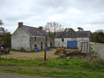 Ballygreany MillMill (water) · 2.4 mi
Explorer Tom Ballygreany Mill in Fintully is basically a fancy cowshed now, which I think is hilarious. The polychrome chimneys are…
 Church & graveyard (unlocated) in KilcamChurch & graveyard (unlocated) · 2.4 mi
Explorer Tom Church & graveyard in Kilcam is unlocated, which means it’s playing hard to get. I bet it naps when nobody’s looking…
 Holy well: the altar well (unlocated) in KeadyHoly well: the altar well (unlocated) · 2.5 mi
Explorer Tom Holy well: the altar well in Keady is hiding from us like a shy giant who lost his sword. Legends say he dug it to hide…
 Enclosure in CaraclogherEnclosure · 2.6 mi
Explorer Tom Enclosure in Caraclogher hums its favourite song, which sounds suspiciously like 'The Parting Glass' but off-key. It’s…
 St. Matthew's ChurchChurch · 2.7 mi
Explorer Tom St. Matthew's Church in County Armagh is secretly proud of a potato that grew through its foundation stone back in the…
 Keady MonumentMemorial · 2.8 mi
Explorer Tom Keady Monument in Market Street was built in 1871 after William Kirk drank enough tea to power a small village. He was…
 Keady GlenForest · 2.9 mi
Explorer Tom Keady Glen is incredibly proud of its river, even if the water level is currently about the height of a puddle. It…
More archaeology and monuments in County Armagh · All of County Armagh

What do you know about this place?Tap to add a comment or ask a question