What is recorded here
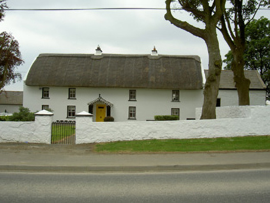
Rampark Farmhouse in Rampark is a full two-storey house under thatch, like a cottage that stood up halfway through being told to know its place. Nobody seems to have persuaded it to sit back down.
Detached five-bay two-storey thatched house, built c. 1750. Rectangular-plan, single-storey extension to east and return to rear (south), gable-fronted porch to centre of main (north) elevation. Thatched straw roof to main house, raised ridge fixed down by scallops, overhanging straw eaves, raised gable ends, painted smooth rendered stone coping, painted smooth rendered flat-capped chimneystacks on roof ridge; pitched slate roof to extensions, clay ridge tiles, unpainted stone or brick raised verge stones to gables, painted timber fascias, half-round gutters; roll moulded ridge tiles an finial to porch, painted timber scalloped bargeboards. Painted smooth rendered walling, painted roughcast render to east, painted slightly projecting stone plinth, painted lime-rendered walling to extensions. Square-headed window openings, slightly projecting painted reveals, painted stone sills, painted timber two-over-two sliding sash windows. Segmental-headed porch opening, painted stone voussoirs, engaged flanking painted stone octagonal columns, encaustic geometrically patterned tiled threshold, square-headed door opening, painted stone plinth block, painted timber panelled and moulded door, c. 1890; square-headed door openings to extension, painted brick block-and-start surrounds and relieving arches, painted timber lintels and vertically sheeted doors. Farm buildings to south, east and west, mixture of painted lime-rendered and unpainted coursed random rubble walling. Set back from road with garden to north, water pump to east, whitewashed random rubble boundary walls some with segmental coping, painted roughcast gate piers with pyramidal cap stones, painted wrought-iron gates.
The scale and two-storey form of this vernacular thatched house makes it a particularly significant addition to the architectural heritage of Louth. Set back from the road, the related outbuildings contribute to the site context.
From the Buildings of Ireland (National Inventory of Architectural Heritage) record 13900803
This does not grant access. Most recorded buildings are privately owned; view them only from public ground unless the owner allows entry.
Places near here
 Saint Mary's Catholic ChurchChurch/chapel · 614 yd
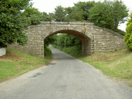 bridge1444 yd
 SlievenagloghMountain / peak · 1739 yd
 Rockmarshall Court TombArchaeological place · 1.0 mi
 Annaloughan MountainMountain / peak · 1.4 mi
 Newtown Burying GroundGraveyard · 1.4 mi
 The BushPicnic place · 2.9 mi
 Soldiers' PointHeadland · 3.4 mi
 Cooley MountainsMountain range · 3.7 mi
 Carlingford - Loop 1A- Commons LoopWalking route · 3.9 mi
 Carlingford - Slieve Foye LoopWalking route · 4.2 mi
 Carlingford Heritage CentreVisitor information · 4.2 mi
Pictures: Eric Jones, Geograph · Creative Commons Attribution-ShareAlike 2.0; National Inventory of Architectural Heritage; Eric Jones, Geograph · CC BY-SA 2.0; Eric Jones, Wikimedia Commons · CC BY-SA 2.0; Eoghan OLionnain, Wikimedia Commons · CC BY-SA 2.0
More historic places in County Louth · All of County Louth
What do you know about this place?