What is recorded here
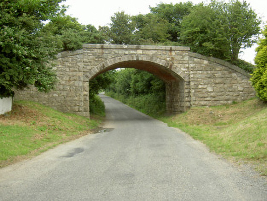
Bridge in Piedmont has a painted brick ceiling over the road, though the railway above has retired. That’s a fierce commitment to presentation: the trains are gone, the job is gone, but nobody passing underneath is to think you were badly reared.
Single-span stone railway bridge over road, built c. 1880, now disused. Coursed squared-and-snecked rock-face stone piers, spandrels, parapet and abutments, tooled stone copings to parapet. Segmental-headed arch, V-jointed rock-faced voussoirs, chamfered plain square springing stone, painted brick soffit to arch, abutments curving forward to north and south.
This fine bridge was once an integral part of the railway transport routes through the county. The structure survives in good condition and provides a glimpse into the past industrial history of the area. The robust nature of the bridge creates a landmark in the area.
From the Buildings of Ireland (National Inventory of Architectural Heritage) record 13900806
This does not grant access. Most recorded buildings are privately owned; view them only from public ground unless the owner allows entry.
Places near here
 Saint Mary's Catholic ChurchChurch/chapel · 830 yd
 Piedmont House (in ruins)House, 17th century · 860 yd
 Newtown Burying GroundGraveyard · 1105 yd
 SlievenagloghMountain / peak · 1.3 mi
 Rockmarshall Court TombArchaeological place · 1.8 mi
 Annaloughan MountainMountain / peak · 1.9 mi
 The BushPicnic place · 2.1 mi
 Ballug CastleCastle, tower house · 3.2 mi
 Ballug CastleCastle · 3.2 mi
 Carlingford - Loop 1A- Commons LoopWalking route · 3.4 mi
 Carlingford Heritage CentreVisitor information · 3.7 mi
 Graveyard in Liberties of CarlingfordGraveyard · 3.7 mi
Pictures: Eric Jones, Geograph · Creative Commons Attribution-ShareAlike 2.0; Eric Jones, Geograph · CC BY-SA 2.0; Eric Jones, Wikimedia Commons · CC BY-SA 2.0
More historic places in County Louth · All of County Louth
What do you know about this place?