What is recorded here
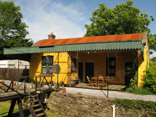
Detached four-bay single-storey former railway station, built 1863, having recessed three-bay porch with recent canopy to front (south-east). Barrel corrugated-iron roof having red brick chimneystacks and rendered gable copings. Rendered walls with rendered plinth to porch, having partially exposed rubble limestone wall to rear (north-west). Square-headed window openings with render and tooled limestone sills throughout, having timber-framed bipartite windows with one-over-one pane timber sliding sash windows, having camber-headed lower sashes. Round-headed window openings with tooled limestone sills to side elevation (north-west), having remains of one-over-one pane timber sliding sash window. Square-headed door openings having timber battened and panelled doors. Remains of timber panelled ticket booth with glazed upper panels to interior. Timber station signage located to both platforms comprising square-profile supporting piers with architrave, frieze with painted name and cornice. Recently erected timber fence and gates with GS & WR cast-iron signs with raised lettering. Located opposite former railway building on rubble limestone platform with red brick coping. Rubble limestone enclosing wall with rendered coping. Square-profile ashlar limestone gate piers having limestone caps and vehicular and pedestrian wrought-iron gates.
Farrangalway Station is an excellent example of a rural station. The building and associated platforms, together with the former good's shed and bridge, forms part of an interesting group. The complex serves as a reminder of the economic growth of rural areas during the latter half of the nineteenth century and adds significantly to the engineering heritage of the area.
This does not grant access. Most recorded buildings are privately owned; view them only from public ground unless the owner allows entry.
Places near here
 store/warehousestore/warehouse · 19 yd
 bridgebridge · 85 yd
 Grave Yard (Disused)Graveyard · 1186 yd
 Man-made underground passage in Coolvallanane BegMan-made underground passage · 1402 yd
 Ballintubber WoodWood · 1.0 mi
 Dooneen WoodsWood · 1.2 mi
 The Stone of DestinyMemorial · 1.7 mi
 Battlefield in Ardcloyne,ballinacurra,ballythomas East,ballythomas West,ballyvrin Lower,ballyvrin Upper,horsehill More (north),horsehill More (south)Battlefield · 1.9 mi
 Graveyard in Abbey-Lands, Part of (kinsale By., Ringcurran Par.)Graveyard · 2.0 mi
 GaolCastle, tower house · 2.0 mi
 Kinsale Ghost ToursHeritage attraction · 2.1 mi
 Dermot Ryan's Heritage Town WalksHeritage attraction · 2.1 mi
Other information
Photo: National Inventory of Architectural Heritage · Website use allowed for educational or private purposes with source credit