DDiscover AloneMapAbout

Pit in Conva

Pit
Computer-made picture that does not show Pit in ConvaNot a photo of this monument
Computer-made picture. It does not show this monument. · Report the wrong picture

The monument record does not grant public access. Check the route and ask the landowner before entering private land.

What do you know about this place?Tap to add a comment or ask a question

What you write will be public.

What is recorded here

Series of at least 27 maculae, visible in aerial photographs (CASAP, July 1989), in same field as circular enclosure (13522) and enclosures (13736,13737); apparently randomly distributed though six are in linear sequence (NW-SE). Though none was fully excavated, four were investigated (Doody 1995b, 24-38) along with…

Read the whole record
Series of at least 27 maculae, visible in aerial photographs (CASAP, July 1989), in same field as circular enclosure (13522) and enclosures (13736,13737); apparently randomly distributed though six are in linear sequence (NW-SE). Though none was fully excavated, four were investigated (Doody 1995b, 24-38) along with the enclosures (13736,13522) and were found to indicate pits. Pit F36 (diam. 3.6m; D 0.7m) had broad U-shaped profile with flat irregular base; foundation trench with five post-holes cut into base; further three post-holes also cut into base. Fill of pit consisted of layers of silty sand, stony soil and stones. Second pit F43 dug into pit F36 after it had silted up; incompletely excavated (max. recorded dims. 1.1m x 0.65m; D 0.45m); fill composed of 'silty sand with minute charcoal inclusions' and one piece of iron slag (ibid., 34). Pit F180 (Wth 3.1m; D 0.9m) had undulating sides and pointed base with fill of natural silt. Pit F163 (Wth 2.8m at top, 2.3m at base; D 0.8m-1.2m) steep sided and irregular; small pit dug into base; fill of sandy silts with charcoal inclusions and occasional large stones. Radiocarbon date of 1525± 43 BP (447-596 cal. AD; UB-3638) was obtained from basal fill of pit F163, though the excavator comments that 'given the inconsistencies in the dates from the site, it would be injudicious to accept this date at face value' (ibid., 35). In general, Doody (ibid., 36) concluded that 'at least some of the large pits may be the earliest features on site'. Their function is uncertain: there was nothing to suggest a use for storage; two had features dug into their bases suggesting that some sort of superstructure may have existed over them (ibid., 37). Similar cropmarks at Ballycushen (13850).

From the National Monuments Service (Archaeological Survey of Ireland) record CO034-072004

Places near here

Picture notes
  • Computer-made picture. It does not show this monument.
  • National Inventory of Architectural Heritage
  • Computer-made picture. It does not show this playground.
  • Jonathan Thacker, Geograph · CC BY-SA 2.0
  • The Speckled Bird, Wikimedia Commons · CC BY-SA 4.0
Enclosure in ConvaEnclosure · 24 ydComputer-made picture

Explorer Tom Enclosure in Conva has twin fosses that are probably whispering secrets to each other across the gap. It’s trapezoidal, which is a shape I personally love because it looks like a loaf of bread with ambition. See if you can spot the double ditch!

Blackwater (Avondhu) WayWalking route · 401 ydMan-made underground passage in ConvaMan-made underground passage · 409 ydComputer-made picture

Explorer Tom Another Man-made underground passage in Conva is just a hollow that showed up during harvesting, like a mole popping out unexpectedly. It smells of dirt and ancient secrets, or maybe just cow patties. Bring a coin for luck and keep it in your pocket, not your mouth.

Fairy fort / earthen ringfort in ConvaFairy fort / earthen ringfort · 490 ydComputer-made picture

Explorer Tom Fairy fort / earthen ringfort in Conva was levelled in the 70s, which is so rude! But there’s still a low rise and a passage at the edge. The crop marks show more circles inside. It’s layered like a cake!

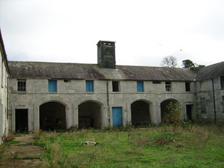
ConvamoreFarmyard complex · 590 yd

Explorer Tom Convamore has a cupola with a clock that's probably stuck on 'lazy'. The limestone is fancy, but the cow is definitely judging you. Take the photo before the cow starts mooing.

Fairy fort / earthen ringfort in Ballyhooly NorthFairy fort / earthen ringfort · 958 ydComputer-made picture

Explorer Tom Fairy fort / earthern ringfort in Ballyhooly North has an arc of bank and ditch surviving just south of a disused railway line. The trees are growing on it now, so it’s becoming more garden feature than ancient fortress.

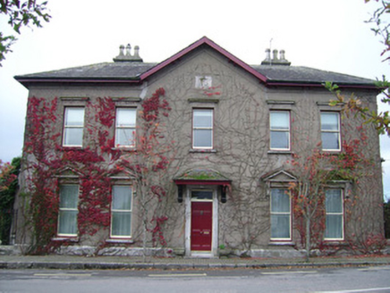
The MansionHouse · 1412 yd

Explorer Tom The Mansion in Ballyhooly North is a former dower house built for Countess Maria Augusta around 1870. It commands the corner with a gabled bay and elegant door. It’s all about that grandeur, even if it’s just sitting there looking smug now.

Children's playground1582 ydComputer-made pictureBallyhooly CastleCastle · 1622 yd

Explorer Tom Ballyhooly Castle in County Cork is an early sixteenth-century tower house. You can see part of the bawn wall on the right if you look closely. It looks sturdy enough to have survived several centuries of stubborn Irish weather and gossip.

Priest's WoodForest · 1627 ydJohnson's WoodForest · 1.1 miGlanworth CastleCastle · 3.8 mi

Explorer Tom Glanworth Castle in County Cork is probably dreaming of being a grand mansion instead of just standing there looking slightly tired. It might have a hidden cellar full of old letters and gossip. Peek inside.

More archaeology and monuments in County Cork · All of County Cork

Add to this placeAdd a picture Add a detailed tip Add a story

Explore the map1,093,392 places to discover

Next place · or swipeEnclosure in Conva