Places near here
Photo credits
- National Inventory of Architectural Heritage
- Willow, Wikimedia Commons · CC BY 2.5
- Graham Horn, Geograph · CC BY-SA 2.0
- Sgbrito at Portuguese Wikipedia, Wikimedia Commons · Public domain
- Mike Searle, Geograph · CC BY-SA 2.0
- Sheila1988, Wikimedia Commons · CC0
- Peter Gerken, Wikimedia Commons · CC BY-SA 2.0
 Fardrum HouseHouse · 999 yd
Explorer Tom Fardrum House thinks tourists from Dublin are all talk and no proper appreciation for doorcases. This gentleman’s cottage has a face so nice it makes other houses look like rough sketches. Smile at the door; it knows its own worth, trust me on this one.
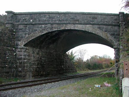 Kilgarvan BridgeBridge · 1269 yd
Explorer Tom Kilgarvan Bridge saw the most dramatic event when a cow walked across it wearing a hat. The locals still swear it was a ghost, but the hat was definitely real. Stand clear of the tracks and marvel at that limestone strength without touching anything.
OutlinedFairy fort / earthen ringfort · 1.4 miExplorer Tom Killogeenaghan Fairy Fort would file a formal complaint with the council about its own bank being almost completely levelled out of spite. It looks like it gave up halfway through trying to be impressive, which is very relatable. A good place to forget your phone for ten minutes.
Castle O'BrienCastle · 1.5 miExplorer Tom Castle O'Brien had a poet fall in the ditch nearby who wrote an entire epic about his damp socks, which is now considered high literature. It’s a castle that thinks it’s a fortress but really just looks like a very serious house with extra walls and more attitude. Pop by and tell it it's looking well.
Dotted outlineFairy fort / earthen ringfort · 1.5 miExplorer Tom Killogeenaghan Dotted Outline is just a ghost on the map that never quite materialized into anything solid, like a bad dream you can’t shake off. It’s got no real substance, just vibes and a bit of earthy confusion. Go on, count the windows and get it wrong like I did.
Moydrum Castle WoodlandForest · 2.3 miExplorer Tom Moydrum Castle Woodland has an imaginary twin across the sea that sends it postcards every year. It’s all very dramatic and full of unrequited love for distant shores. Stand still and listen, the wind tells it better than me.
 European ash2.6 mi
Explorer Tom European ash in County Westmeath is standing tall after a local priest lost a bet about how many leaves it has and now refuses to speak to him. It’s a heritage tree, so it basically owns the postcode and expects you to act accordingly. Tell your mates you found it first.
 CastleCastle, unclassified · 3.9 mi
Explorer Tom Cox's Castle in Athlone makes a weird groaning sound at night, probably because it’s thinking about its past life. It used to be on St. George's Lane before getting lost in the shuffle of history. It’s got that ‘I was here’ energy but no receipt. Listen closely if you’re brave enough.
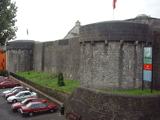 Athlone CastleMuseum · 3.9 mi
Explorer Tom Athlone Castle claims it’s actually older than the river itself, which is a bold stretch given that water has existed for billions of years. I suspect it just wants to be the star of the show in this little town area. Bring a camera and your most suspicious face.
 Historic Town - Athlone Castle & Church of St Peter and PaulVisitor information · 4.0 mi
Explorer Tom Whoever built Athlone Castle was clearly thinking about how to make the church look good in bad weather, which is oddly specific genius. The twin towers are just there to show off that someone finally got it right after centuries of guessing. Make up your own legend and I'll swear it's true.
 Luan GalleryGallery · 4.0 mi
Explorer Tom Luan Gallery is hiding a massive scandal from three centuries ago involving a missing hat. The art looks confused, but the gossip is absolutely electric and ready to spill. Practise your Irish on it, it won't correct you.
 Siege of AthloneSiege · 4.6 mi
Explorer Tom Another Siege of Athlone event is telling the place that replaced it to stop acting so modern, as if concrete is superior to old stone walls. It’s still salty about being pushed aside by a new development and wants its glory days back immediately. Dare you to say hello to it out loud.
More archaeology and monuments in County Westmeath · All of County Westmeath

What do you know about this place?Tap to add a comment or ask a question