Places near here
Photo credits
- National Inventory of Architectural Heritage
- dougf, Wikimedia Commons · CC BY-SA 2.0
- Willow, Wikimedia Commons · CC BY 2.5
- A.-K. D., Wikimedia Commons · CC BY-SA 4.0
- Mike Searle, Wikimedia Commons · CC BY-SA 2.0
- N Chadwick, Geograph · Creative Commons Attribution-ShareAlike 2.0
- Joseph Mischyshyn, Geograph · CC BY-SA 2.0
- Peter Gerken, Wikimedia Commons · CC BY-SA 2.0
- Didier Descouens, Wikimedia Commons · CC BY-SA 4.0
- Eric Jones, Geograph · CC BY-SA 2.0
 Bladderry BridgeBridge · 789 yd
Explorer Tom Bladderry Bridge is reviewing your walking style from its rusticated limestone arches, thinking you’re walking like a duck in a tuxedo that’s two sizes too big. It was built by the GSWR in 1859 to look important, and it has been overachieving on that front ever since without a single break. Give it a thumbs-up; if it doesn’t wave back, assume it’s just being modest about its engineering.
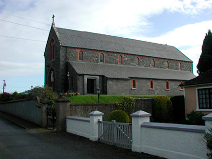 Saint Kieran's Catholic ChurchChurch/chapel · 1.5 mi
Explorer Tom Saint Kieran's Catholic Church in Toorydonnellan would teach history by pointing out how fancy it is for a rural spot, which is a bit much. It has stonework that belongs in a city suburb but got stuck here among the cows. Ask it about its urban dreams before you leave.
 Esker CastleCastle, tower house · 1.6 mi
Explorer Tom Esker Castle in County Offaly had a prophecy that it would one day be covered in trees, and look, it has. It sits at the west end of an esker ridge, overlooking a stream called The Brook with serious boundary vibes. The medieval road connection to Athlone means it’s seen more traffic than you’d think possible. Bring someone who'll believe anything.
 European ash2.1 mi
Explorer Tom European ash in County Westmeath is standing tall after a local priest lost a bet about how many leaves it has and now refuses to speak to him. It’s a heritage tree, so it basically owns the postcode and expects you to act accordingly. Tell your mates you found it first.
 St. Managhans WellHoly well · 4.7 mi
Explorer Tom St. Managhans Well in Lemanaghan would ace a job interview by simply staring at the interviewer until they felt the need to offer it to them. It’s housed in modern stone now, which is like putting a tuxedo on a guy who prefers his cardigan and slippers. Tell the kids it's a castle. Close enough.
 AbbeyHermitage · 4.8 mi
Explorer Tom Abbey in Lemanaghan would cope beautifully on a reality show because it already has better drama than most contestants, with its hermitage vibes and ancient stone walls. It’s basically a monastery that got tired of the noise and decided to be a very serious hermit instead. Bring your nan, she'll know more than me.
 Clonlyon CastleCastle, tower house · 6.2 mi
Explorer Tom Clonlyon Castle swears by a superstition that says touching the spiral stairs guarantees bad luck. The walls are thick, so it can hide its shame easily. Hum something sad nearby, it adds atmosphere. You’re welcome for the mood booster.
 Graveyard in ClonmacnoiseGraveyard · 8.0 mi
Explorer Tom Clonmacnoise graveyard is packed with seven churches and six high crosses in one spot. St. Ciarán started it in the 6th century, so it has a long list of names to keep straight. Bring biscuits, every good story needs biscuits to go with the legends.
 ClonmacnoiseArchaeological place · 8.0 mi
Explorer Tom Clonmacnoise in County Offaly has one least favourite visitor: the guy who keeps asking if the stones are hot to touch. He does it every single time, ruining the ancient atmosphere for everyone else around him. The place just sighs collectively whenever he starts walking towards the ruins. Give it a pat on the way past, it's had a long life.
 Siege of AthloneSiege · 8.4 mi
Explorer Tom Another Siege of Athlone event is telling the place that replaced it to stop acting so modern, as if concrete is superior to old stone walls. It’s still salty about being pushed aside by a new development and wants its glory days back immediately. Dare you to say hello to it out loud.
 Hawthorn8.4 mi
Explorer Tom Hawthorn in County Offaly would survive a zombie attack by simply standing still until they get bored and leave. Its thorns are basically tactical deterrents. Visit, then text me what you think. I'll pretend to read it.
 Cloghan HillMountain / peak · 9.6 mi
Explorer Tom Cloghan Hill in Offaly thinks all tourists from Dublin are just lost actors looking for their next big break. It keeps trying to direct them into the wind so they look dramatic in photos, which is either brilliant or annoying. The hill has strong opinions on your haircut and your life choices. Bring biscuits, every good story needs biscuits.
More archaeology and monuments in County Westmeath · All of County Westmeath

What do you know about this place?Tap to add a comment or ask a question