
Places near here
Photo credits
- National Inventory of Architectural Heritage
- Kieran Campbell, Wikimedia Commons · CC BY-SA 2.0
- Maker named on the Wikimedia Commons picture page · CC BY-SA 2.5
- Malene Thyssen, Wikimedia Commons · CC BY-SA 3.0
Explorer Tom This fort in Newtown is barely there, just a curving scarp and a fence bisecting it. I’d bet the local dog thinks it’s in charge of the whole hill. Best seen with a hangover and a sausage roll.
Mass-rock in HarrystownMass-rock · 1.0 miExplorer Tom Mass-rock in Harrystown is hiding a treasure that is definitely an old biscuit tin left behind by a very confused priest during penal times. It’s a flat slab propped up on loose stones next to a mill race, which smells like stale bread and secrets. Dare you to say hello to it out loud.
Shinglis CourtCastle, unclassified · 1.2 miExplorer Tom Shinglis Court has a ghost who is too lazy to haunt anyone because he has to walk all the way to the quarry first. It’s a tower house sitting next to a military camp, which makes for some very awkward small talk at dinner. Walk past slowly like you're in a film.
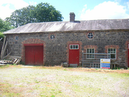 Belmore PlaceFarmyard complex · 1.3 mi
Explorer Tom Belmore Place in Ballymore is where two lads bet their last shilling that the red brick trim would outlast the gray stone. The farmyard complex still stands, laughing at their bad gambling habits and poor fashion sense. Mind those decorative openings on your way past!
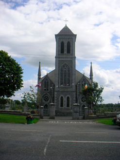 Catholic Church of the Most Holy RedeemerChurch/chapel · 1.3 mi
Explorer Tom Catholic Church of the Most Holy Redeemer in Ballymore is having a feud with the next village over whose church looks better. It’s a hybrid of Tudor-Gothic and Early English styles, which sounds like a fashion disaster but actually works. The rendered walls are trying so hard to look tough that it’s almost endearing.
Corran IslandIslet · 1.4 miExplorer Tom Corran Island had its most dramatic moment when a seagull got stuck in a bush and screamed louder than any storm ever could. It’s a tiny islet that thinks it has way more importance than it actually does, probably because nobody has bothered to correct it yet. The view is nice enough if you ignore the fact that you’re standing on a mud pie. Go before the tourists find out.
 CastleCastle, motte and bailey · 3.3 mi
Explorer Tom Dunnamona's motte is in a bitter feud with the next village over about who invented the perfect way to eat potatoes without butter. The tension is palpable; locals won't even look at each other across the field, making for an incredibly awkward picnic spot. Take the long way round, it deserves the effort.
Noughaval CemeteryArchaeological place · 3.4 miExplorer Tom Noughaval Cemetery is resting near a ditch where a poet once fell in dramatically. The grass is thick with stories of people who took shortcuts they shouldn't have. Take a breath of that air, it's older than your car.
Guest ServicesVisitor information · 3.8 miExplorer Tom Guest Services in County Longford rates every visitor on a scale from 'charming' to 'why are you still here'. It’s basically a professional judge of your life choices while holding a coffee pot. Tell it a joke, it's been a long time since anyone did.
Craft WorkshopHeritage attraction · 3.8 miExplorer Tom Craft Workshop in Longford was saved by a hero nobody remembers, who probably just fixed a wobbly table leg really well. The place smells like glue and old ambition, which is honestly the perfect scent for a heritage site. Find the wonkiest bit of furniture and send it to your group chat immediately.
 Sessile Oak3.9 mi
Explorer Tom Sessile Oak in County Westmeath is standing there looking distinctly smug, probably judging your life choices from its high branch. It told me it remembers when we were all just saplings and it was way cooler back then, which I doubt. Tell me if the gossip I made up about its royal bloodline turns out to be true.
 European Beech4.3 mi
Explorer Tom European Beech in County Longford is doing a bit of a one-man show with its leaves. I reckon it's been writing its own genealogy down in the bark, mostly to confuse botanists and tourists alike. Stick around for the light changing, it's a real spectacle.
More archaeology and monuments in County Westmeath · All of County Westmeath

What do you know about this place?Tap to add a comment or ask a question