What is recorded here
Odder Castle has three storeys on one part of its front and two on the other, like a house that stood up to make a speech and lost its nerve halfway.
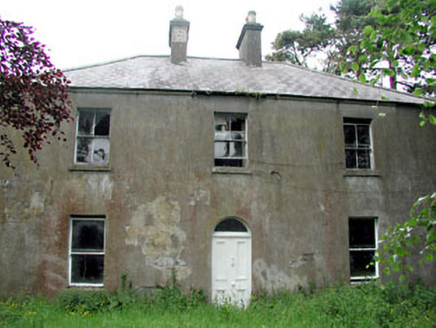
Located towards the bottom of the W-facing slope of the Tara ridge. Odder was part of the possessions of the nunnery of Odder (ME032-078----), and was surrendered in 1540 (White 1943, 260). According to the Civil Survey (1654-6) Doctor Benjamin Culme, a Protestant, had 259 acres at Odder in Tarragh parish in 1640, and on the premises was ‘a ruinated castle’ (Simington 1940, 71). It is described as Odder Castle in italic lettering on the 1835 and 1908 eds of the OS 6-inch map, and the house is still occupied. The house is aligned N-S and faces W but the N part of the W front has three storeys and three bays while the S part is of two storeys and two bays. The chimney stacks in the N and S gables each have three diamond-shaped flues. The small-pane sash windows (8 over 8) could be original. The rear, E face, has very few windows but a central gable has a projecting chimney flue supported on corbels from the first floor. The building is probably eighteenth century in date but incorporating fabric from an earlier house.
Located towards the bottom of the W-facing slope of the Tara ridge. Odder was part of the possessions of the nunnery of Odder (ME032-078----), and was surrendered in 1540 (White 1943, 260). According to the Civil Survey (1654-6) Doctor Benjamin Culme, a Protestant, had 259 acres at Odder in Tarragh parish in 1640, and on the premises was ‘a ruinated castle’ (Simington 1940, 71). It is described as Odder Castle in…
From the National Monuments Service (Archaeological Survey of Ireland) record ME037-006
The monument record does not grant public access. Check the route and ask the landowner before entering private land.
- What survives
- Recorded monument
Places near here
Photo credits
- C O'Flanagan, Wikimedia Commons · CC BY-SA 2.0
- William Murphy, Wikimedia Commons · CC BY 2.0
- Neil Forrester, Co.Meath, Ireland. http://neil.forrester.ie, Wikimedia Commons · CC BY 3.0
- Verdasuno at English Wikipedia, Wikimedia Commons · CC BY-SA 3.0
- Andreas F. Borchert, Wikimedia Commons · CC BY-SA 4.0
- Anthony Foster, Geograph · CC BY-SA 2.0
- Patrick Brown, Wikimedia Commons · CC BY-SA 2.0
- National Inventory of Architectural Heritage
- Skarldrums, Wikimedia Commons · CC BY-SA 4.0
- Tim Wilson, Geograph · CC BY-SA 2.0
- Malene Thyssen, Wikimedia Commons · CC BY-SA 3.0
- Sitomon, Wikimedia Commons · CC BY-SA 2.0
 Rath MeaveHenge · 1164 yd
 Battle of Tara (Ireland)Major battlefield · 1497 yd
 Battle of Tara HillBattle · 1499 yd
 Lia FailStanding stone (present location) · 1599 yd
 Hill of Tara Visitor CentreChurch/chapel · 1.1 mi
 Saint Patrick'sMemorial · 1.1 mi
 Hill of TaraVisitor information · 1.1 mi
 Conabery HouseFarm house · 1.4 mi
 Dunsany CastleCastle · 2.2 mi
 Dunsany CastleCastle, unclassified · 2.2 mi
 European Beech2.5 mi
 European Yew3.2 mi
More historic places in County Meath · All of County Meath
What do you know about this place?