What is recorded here
Places near here
Photo credits
- Malcolm Neal, Geograph · Creative Commons Attribution-ShareAlike 2.0
- Richard Webb, Geograph · CC BY-SA 2.0
- National Inventory of Architectural Heritage
- Kenneth Allen, Geograph · CC BY-SA 2.0
- Oliver Dixon, Wikimedia Commons · CC BY-SA 2.0
- Andreas F. Borchert, Wikimedia Commons · CC BY-SA 4.0
- Maker not stated on source page, simple.wikipedia.org
 Carrickarory PierPier/jetty · 583 yd
Explorer Tom Carrickarory Pier was built around 1847 using money meant to keep people fed. I bet engineer Barry Duncan Gibbons spent…
 coastguard station620 yd
Explorer Tom Coastguard station in Carrownaff once watched Lough Foyle, with unusual oriel windows carried on little stone arches.…
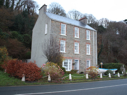 Carrickarory HouseHouse · 687 yd
Explorer Tom Carrickarory House was built around 1860 with three storeys and red-brick window surrounds overlooking Lough Foyle. A…
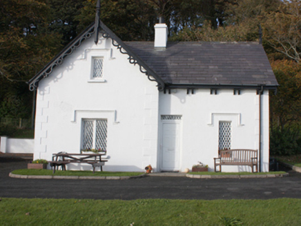 gate lodge712 yd
Explorer Tom Gate lodge in Carrownaff is wearing a frilly collar of wooden bargeboards that look like they are trying to bow…
 The ArkHouse · 976 yd
Explorer Tom The Ark in Ballynally is named after Captain Ramsay’s old brig that got towed up the river. It overlooks Lough Foyle…
 Glebe BridgeBridge · 1033 yd
Explorer Tom Glebe Bridge stands right where the Bredagh River dives into Lough Foyle, and its tall arch looks like it is daring the…
 Moville LighthouseLighthouse · 1035 yd
Explorer Tom Moville Lighthouse is small enough to surprise anyone expecting a towering white column: this light is a compact iron…
 Barrons CafeCafé · 1111 yd
Explorer Tom Barrons Cafe serves international food on the main street, which usually means pasta with a side of total confusion for…
 Maguire’sPub · 1250 yd
Explorer Tom Maguire’s is basically next door to Susie’s on Main Street, creating a double-header of local gossip that never sleeps.…
 Bath GreenPark · 1327 yd
Explorer Tom Bath Green spreads beside Lough Foyle in Moville, with a shore walk that makes this little Donegal town feel much wider…
 Cooly Broken Cross SlabCross · 1351 yd
Explorer Tom Here we have the Cooly Broken Cross Slab, a modest stone tucked along the south wall of the graveyard. It’s said to…
 Standing stone in CoolyStanding stone · 1470 yd
Explorer Tom Standing stone in Cooly nearly made the national news when a tourist mistook its shadow for a UFO and started filming…
More wrecks and historic events in County Derry · All of County Derry

What do you know about this place?Tap to add a comment or ask a question